IMAGES TAKEN NEAR TO
SO3 4BZ
Introduction
This page details the photographs taken nearby to SO3 4BZ by members of the Geograph project.
The Geograph project started in 2005 with the aim of publishing, organising and preserving representative images for every square kilometre of Great Britain, Ireland and the Isle of Man.

There are currently over 7.5m images from over14,400 individuals and you can help contribute to the project by visiting https://www.geograph.org.uk
Image Map
Images are licensed for reuse under creativecommons.org/licenses/by-sa/2.0
Notes
- Clicking on the map will re-center to the selected point.
- The higher the marker number, the further away the image location is from the centre of the postcode.
Image Listing (28 Images Found)
Images are licensed for reuse under creativecommons.org/licenses/by-sa/2.0
Image
Details
Distance
1
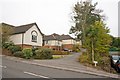
Waylands Place
A newish residential cul de sac the end of which affords access to private grass land on Sunday's Hill.
Image: © Peter Facey
Taken: 4 Nov 2008
0.01 miles
2
Ayerswood, Dodwell Lane
A newish residential cul de sac.
Image: © Peter Facey
Taken: 4 Nov 2008
0.05 miles
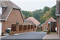
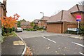
3
Development by Lainston Homes in Bursledon Road
"A select development of 14 one and two bedroom apartments". Although the notice says "Sunday's Hill" that is actually the hill beyond. The development occupies the site of a former filling station and garage. Foord Road is the turning to the right in the foreground. Behind these apartments is Paling Business Park.
Image: © Peter Facey
Taken: 4 Nov 2008
0.05 miles
4
Corner of Bursledon Road and Heath House Lane
Looking from Bursledon Road across the corner at Heath House Lane. The property at left, seen edge on, is numbers 1 to 4 The Haven.
Image: © Peter Facey
Taken: 4 Nov 2008
0.06 miles
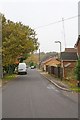
5
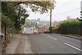
Dodwell Lane descends Sunday's Hill
The turning to the right in the distance is Heath House Lane.
Image: © Peter Facey
Taken: 4 Nov 2008
0.06 miles
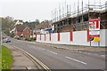
6
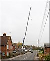
Big crane on building site, Bursledon Road
This crane was lifting concrete floor beams. See also Image
Image: © Peter Facey
Taken: 4 Nov 2008
0.07 miles
7
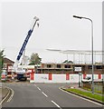
Development by Lainston Homes on Bursledon Road
Seen from Heath House Lane. The development occupies the site of a former filling station and garage. It is of "14 well-appointed one and two bedroom apartments". The crane was being used to lift concrete floor beams into place.
Image: © Peter Facey
Taken: 4 Nov 2008
0.07 miles
8
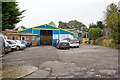
Paling Business Park, Foord Road
The blue shed houses Sunday's Hill MoT Centre. To its right is Keystone Construction Ltd.
Image: © Peter Facey
Taken: 4 Nov 2008
0.07 miles
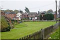
9
Boundary Acre, Dodwell Lane
The unusual road name sign, perhaps required by the person who sold the land for this development, adds '"Boundary Acre" was the name of the house formerly standing on this site'.
Image: © Peter Facey
Taken: 4 Nov 2008
0.10 miles
10
Foord Road
Downland Place is on the left beyond the white van.
Image: © Peter Facey
Taken: 4 Nov 2008
0.12 miles