IMAGES TAKEN NEAR TO
SO3 4BA
Introduction
This page details the photographs taken nearby to SO3 4BA by members of the Geograph project.
The Geograph project started in 2005 with the aim of publishing, organising and preserving representative images for every square kilometre of Great Britain, Ireland and the Isle of Man.

There are currently over 7.5m images from over14,400 individuals and you can help contribute to the project by visiting https://www.geograph.org.uk
Image Map
Images are licensed for reuse under creativecommons.org/licenses/by-sa/2.0
Notes
- Clicking on the map will re-center to the selected point.
- The higher the marker number, the further away the image location is from the centre of the postcode.
Image Listing (17 Images Found)
Images are licensed for reuse under creativecommons.org/licenses/by-sa/2.0
Image
Details
Distance
1
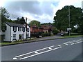
View into Upper Northam Close
Long ago, before the construction of the M27, the road in the foreground continued straight ahead past the white house and on towards Southampton. The main road now bears right to Junction 7 on the motorway, while the route straight ahead has been downgraded to a footpath through a tunnel.
Image: © David Martin
Taken: 22 Jun 2012
0.05 miles
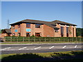
3
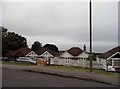
Bungalows on Upper Northam Road, Hedge End
Image: © David Howard
Taken: 24 Jul 2016
0.10 miles
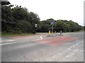
5
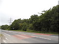
Borough of Eastleigh : M27 Motorway
The M27 Motorway between Junction 7 (Hedge End Interchange) and Junction 8 (Windhover Interchange).
Image: © Lewis Clarke
Taken: 28 Mar 2018
0.17 miles
6
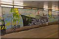
Mural and graffiti in subway south of M27 junction 7
Presumably in the hope of discouraging the more mindless kind of graffiti, the authorities (I presume) arranged for a mural to be painted here depicting a map of the world with pictures of different modes of transport appropriate to the international maritime city of Southampton. Here we see (L to R) a Land Rover, an ocean liner, and an aeroplane. Sadly, the plan didn't work, as can also be seen.
Image: © Peter Facey
Taken: 14 Jul 2009
0.17 miles
7
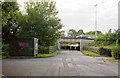
Subway beneath M27 south of junction 7
The M27 cut Upper Northam Drive in two, and the part on the near (east) side of the M27 became Upper Northam Close. The hut on the left houses an 11KV/400 electricity substation.
Image: © Peter Facey
Taken: 14 Jul 2009
0.19 miles
9
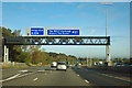
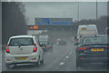
M27 junction 7
One of the newer style of sign gantry, installed much later than the road was built.
Image: © Robin Webster
Taken: 30 Oct 2012
0.21 miles
10
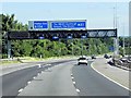
Sign Gantry over the M27 near Thornhill
Image: © David Dixon
Taken: 20 Jul 2013
0.21 miles