IMAGES TAKEN NEAR TO
Barnes Close, WINCHESTER, SO23 9QX
Introduction
This page details the photographs taken nearby to Barnes Close, SO23 9QX by members of the Geograph project.
The Geograph project started in 2005 with the aim of publishing, organising and preserving representative images for every square kilometre of Great Britain, Ireland and the Isle of Man.

There are currently over 7.5m images from over14,400 individuals and you can help contribute to the project by visiting https://www.geograph.org.uk
Image Map
Images are licensed for reuse under creativecommons.org/licenses/by-sa/2.0
Notes
- Clicking on the map will re-center to the selected point.
- The higher the marker number, the further away the image location is from the centre of the postcode.
Image Listing (90 Images Found)
Images are licensed for reuse under creativecommons.org/licenses/by-sa/2.0
Image
Details
Distance
1
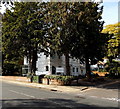
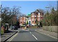
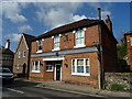
Winchester Orthodontic Practice
Located on the corner of Barnes Close and St Cross Road in the south of Winchester.
Image: © Jaggery
Taken: 28 Sep 2014
0.04 miles
3
Christchurch Road, Winchester
Looking NNE from the Lower Stanmore Lane end.
Image: © Jaggery
Taken: 28 Sep 2014
0.06 miles
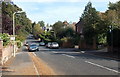
4
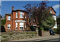
Barnes Close, Winchester
In late September 2014, Barnes Close is a through road from Christchurch Road behind the camera to
St Cross Road ahead. Presumably it was named at a time when one of these road junctions did not exist.
Image: © Jaggery
Taken: 28 Sep 2014
0.06 miles
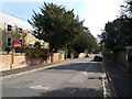
5
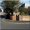
Barnes Close Gas Installation, Winchester
On the corner of Barnes Close and Christchurch Road, a padlocked brown door leads to a Southern Gas Networks gas installation. A notice shows a phone number to call before beginning any work on or within 10 metres of this site, or in an emergency.
Image: © Jaggery
Taken: 28 Sep 2014
0.06 miles
6
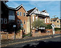
Wykeham House flats, Winchester
Viewed across Christchurch Road near the Barnes Close junction.
The nameplate on the wall shows WYKEHAM HOUSE FLATS 4 5 6.
Image: © Jaggery
Taken: 28 Sep 2014
0.07 miles
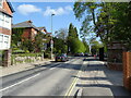
8
Kingsgate Road approaches St Cross Road
Image: © Steve Daniels
Taken: 17 Mar 2016
0.08 miles
9
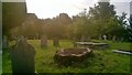
Base of a very large tree in St Faith's Churchyard Winchester
St Faith's was demolished in 1507 and St Cross (down the road) has been used as the parish church since then. The churchyard seems to have been used up until comparatively recently. There are two military graves from World War One.
Image: © Tim Hodgins
Taken: 10 Sep 2013
0.08 miles
10
The former Wheatsheaf public house on St Cross Road
Image: © JThomas
Taken: 29 Apr 2022
0.09 miles