IMAGES TAKEN NEAR TO
Vigus Close, WINCHESTER, SO23 7GW
Introduction
This page details the photographs taken nearby to Vigus Close, SO23 7GW by members of the Geograph project.
The Geograph project started in 2005 with the aim of publishing, organising and preserving representative images for every square kilometre of Great Britain, Ireland and the Isle of Man.

There are currently over 7.5m images from over14,400 individuals and you can help contribute to the project by visiting https://www.geograph.org.uk
Image Map (Loading...)


Getting Data...Please wait
Leaflet Map data © OpenStreetMap
Images are licensed for reuse under creativecommons.org/licenses/by-sa/2.0
Notes
- Clicking on the map will re-center to the selected point.
- The higher the marker number, the further away the image location is from the centre of the postcode.
Image Listing (13 Images Found)
Images are licensed for reuse under creativecommons.org/licenses/by-sa/2.0
Image
Details
Distance
1

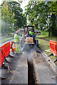
Cutting a trench in Campion Way
After the top part of the trench has been cut by the Case 660 trencher fitted with a TC400X Top Cutter, it can be dug out further either by hand (around obstacles) or using the small red-coloured digger seen here (but fitted with a narrower bucket). In this photo a wider bucket was being used simply to push the spoil back into the trench for safety reasons, it not being intended to lay the electricity cable that day.
Image: © Peter Facey
Taken: 27 Sep 2012
0.05 miles
2
Cutting a trench in Campion Way
A Case 660 trencher, fitted on the back with a TC400X Top Cutter being used to cut through the tarmac and the top part of the road bed to make a trench into which a new 11KV electricity cable can be laid. The advantages of using this equipment is that it leaves a clean edge, its height (or cutting depth) can be adjusted to avoid any buried pipes, and the resulting trench is fairly narrow.
Image: © Peter Facey
Taken: 27 Sep 2012
0.06 miles
3

Cutting a trench in Campion Way
A Case 660 trencher, fitted on the back with a TC400X Top Cutter being used to cut through the tarmac and the top part of the road bed to make a trench into which a new 11KV electricity cable can be laid. The advantages of using this equipment is that it leaves a clean edge, its height (or cutting depth) can be adjusted to avoid any buried pipes, and the resulting trench is fairly narrow.
Image: © Peter Facey
Taken: 27 Sep 2012
0.06 miles
4
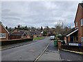
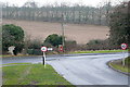
Nations Hill
A sliver of Nations Hill, a lovely suburban road in the expanding village of King's Worthy, just creeps into the north-east corner of this square.
Image: © Graham Horn
Taken: 14 Feb 2010
0.07 miles
5
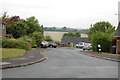
Junction of Glendeep Close with Bentley Close
Image: © Basher Eyre
Taken: 17 Feb 2023
0.11 miles
6
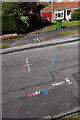
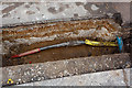
Road marked up to show all buried utilities in Campion Way
Yellow - gas, blue - water, red - electricity, white - telephone, cable TV, fibre optics. Depths are also shown where this can be measured, which is not the case with fibre optics unless an electrical tracing wire has been laid together with the fibre.
Image: © Peter Facey
Taken: 27 Sep 2012
0.12 miles
7
End of Nations Hill
The suburban road, Nations Hill, ends here at its junction with Springvale Road, which marks, for now, the limit of the urban area.
Image: © Graham Horn
Taken: 14 Feb 2010
0.14 miles
8
Join in newly-laid 11KV electricity cable
Image: © Peter Facey
Taken: 27 Sep 2012
0.17 miles
9
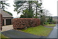
Field End, Kings Worthy
A short cul-de-sac off the end of Campion Way.
Image: © Trevor Harris
Taken: 6 Sep 2013
0.19 miles
10
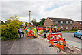
Laying new 11KV electricity cables in Campion Way
Contractors Durkin working on behalf of Scottish & Southern Electricity. The top part of the trench for the cable is cut by the TC400X Top Cutter equipment seen in the background.
Image: © Peter Facey
Taken: 27 Sep 2012
0.19 miles