IMAGES TAKEN NEAR TO
Drove Hill, STOCKBRIDGE, SO20 6AR
Introduction
This page details the photographs taken nearby to Drove Hill, SO20 6AR by members of the Geograph project.
The Geograph project started in 2005 with the aim of publishing, organising and preserving representative images for every square kilometre of Great Britain, Ireland and the Isle of Man.

There are currently over 7.5m images from over14,400 individuals and you can help contribute to the project by visiting https://www.geograph.org.uk
Image Map
Images are licensed for reuse under creativecommons.org/licenses/by-sa/2.0
Notes
- Clicking on the map will re-center to the selected point.
- The higher the marker number, the further away the image location is from the centre of the postcode.
Image Listing (14 Images Found)
Images are licensed for reuse under creativecommons.org/licenses/by-sa/2.0
Image
Details
Distance
1
Little Drove Road, Chilbolton
From its junction with Station Road. There are fields on the right on the former Chilbolton Airfield site.
Image: © Peter Facey
Taken: 29 May 2008
0.06 miles
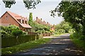
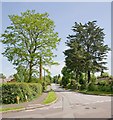
2
Drove Hill, Chilbolton
A residential cul de sac off Drove Road.
Image: © Peter Facey
Taken: 29 May 2008
0.06 miles
3
Eastmans Field and Drove Road, Chilbolton
Eastmans Field is a small residential cul de sac off Drove Road. It also contains the village hall.
Image: © Peter Facey
Taken: 29 May 2008
0.07 miles
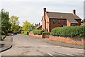
4

Car Park at Village Hall, Drove Road, Chilbolton
With one of Hampshire County Council's mobile library lorries. Part of the hall is seen at right.
Image: © Peter Facey
Taken: 29 May 2008
0.09 miles
5

Chilbolton Village Hall
Large and modern hall on the south side of the large Test Valley village.
Image: © Colin Smith
Taken: 30 Aug 2010
0.10 miles
6
Chilbolton: Station Road
The name of this road has left the photographer perplexed! Looking at old maps there has evidently never been a railway here yet alone a station, the nearest being Fullerton Junction which was some distance and a couple of intermediate roads away. One walking website suggests it was so named as it headed off in the general direction of that station from the Second World War airfield on the downs above the village, providing guidance to wartime personnel, but that theory must be wrong as the road is clearly shown and named on the Ordnance Survey map of 1910, prior to the First World War, let alone the Second. It cannot be anything to do with Chilbolton Observatory either as its construction did not start until 1963. So was it a road to a station on a railway that was never eventually built? Or does the word Station have a non-railway meaning here?
Image: © Nigel Cox
Taken: 20 Sep 2013
0.11 miles
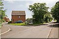
7

Village Hall, Drove Road, Chilbolton
A newish hall built with funds from the Millennium Commission.
Image: © Peter Facey
Taken: 29 May 2008
0.12 miles
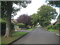
8

Drove Road approaching Coley Lane, Chilbolton
With Durnford Close on right.
Image: © Peter Facey
Taken: 29 May 2008
0.14 miles
9

Station Road, Chilbolton
Seen from its SE end at a T junction with Little Drove Road. This is a leafy residential area.
Image: © Peter Facey
Taken: 29 May 2008
0.14 miles
10
Branksome Avenue, Chilbolton
Seen across Station Road.
Image: © Peter Facey
Taken: 29 May 2008
0.18 miles