IMAGES TAKEN NEAR TO
Little Drove Road, STOCKBRIDGE, SO20 6AN
Introduction
This page details the photographs taken nearby to Little Drove Road, SO20 6AN by members of the Geograph project.
The Geograph project started in 2005 with the aim of publishing, organising and preserving representative images for every square kilometre of Great Britain, Ireland and the Isle of Man.

There are currently over 7.5m images from over14,400 individuals and you can help contribute to the project by visiting https://www.geograph.org.uk
Image Map
Images are licensed for reuse under creativecommons.org/licenses/by-sa/2.0
Notes
- Clicking on the map will re-center to the selected point.
- The higher the marker number, the further away the image location is from the centre of the postcode.
Image Listing (24 Images Found)
Images are licensed for reuse under creativecommons.org/licenses/by-sa/2.0
Image
Details
Distance
1

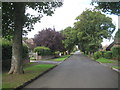
Station Road, Chilbolton
Seen from its SE end at a T junction with Little Drove Road. This is a leafy residential area.
Image: © Peter Facey
Taken: 29 May 2008
0.03 miles
2
Chilbolton: Station Road
The name of this road has left the photographer perplexed! Looking at old maps there has evidently never been a railway here yet alone a station, the nearest being Fullerton Junction which was some distance and a couple of intermediate roads away. One walking website suggests it was so named as it headed off in the general direction of that station from the Second World War airfield on the downs above the village, providing guidance to wartime personnel, but that theory must be wrong as the road is clearly shown and named on the Ordnance Survey map of 1910, prior to the First World War, let alone the Second. It cannot be anything to do with Chilbolton Observatory either as its construction did not start until 1963. So was it a road to a station on a railway that was never eventually built? Or does the word Station have a non-railway meaning here?
Image: © Nigel Cox
Taken: 20 Sep 2013
0.05 miles
3
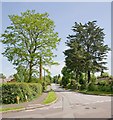
Branksome Avenue, Chilbolton
Seen across Station Road.
Image: © Peter Facey
Taken: 29 May 2008
0.11 miles
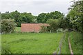
4
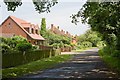
Little Drove Road, Chilbolton
From its junction with Station Road. There are fields on the right on the former Chilbolton Airfield site.
Image: © Peter Facey
Taken: 29 May 2008
0.11 miles
5
Equipment room, Chilbolton radio telescope
The raised portakabin-like building is one of a pair that face each other 500 metres apart. See Image
Image: © Peter Facey
Taken: 29 May 2008
0.15 miles
6
WWII building of former Chilbolton Airfield
The building seems to be disused. It has roof-level air vents suggesting forced ventilation. This one is on the OS maps, unlike Image
Image: © Peter Facey
Taken: 20 May 2008
0.16 miles
7
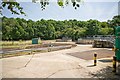
Wastewater Treatment Works, Chilbolton
Operated by Southern Water. Site reference number 102902.
Image: © Peter Facey
Taken: 29 May 2008
0.19 miles
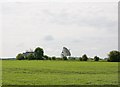
8
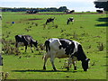
Cattle grazing on West Down
On the chalk grassland south-west of Chilbolton in the Test Valley.
Image: © Colin Smith
Taken: 30 Aug 2010
0.19 miles
9

The Mark Way on West Down, Chilbolton
A permissive bridleway which here runs parallel to a footpath.
Image: © Peter Facey
Taken: 20 May 2008
0.20 miles
10
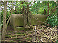
WWII Hampshire - RAF Chilbolton Battle HQ (1)
-
Airfield Battle Headquarters: DoB ID: e28387
The familiar square cupola of an airfield Battle Headquarters dating from the earliest part of the Second World War lies hidden in dense undergrowth in a field alongside the footpath. Most RAF airfields built these as control centres in the event the airfield was overrun by enemy forces. This was the Battle HQ of the former wartime airfield of RAF Chilbolton, and is a standard type having a single cupola with viewing slits set just above ground level.
RAF Chilbolton airfield was opened in Sept 1940 as a satellite of RAF Middle Wallop, and was in use as a relief landing ground. It very soon was pressed into service during the latter stages of the Battle of Britain when it hosted its own Hawker Hurricane squadrons flying Mk1's. Later in the war the airfield was substantially upgraded with concrete runways, a perimeter track, and dispersal pens when various USAAF squadrons were based here. The airfield was handed back to the RAF in 1945, and was the first RAF station to fly the new De Havilland Vampire jet aircraft. The station closed in 1946.
Image
Image: © Mike Searle
Taken: 2 Jun 2016
0.20 miles