IMAGES TAKEN NEAR TO
Robert Cecil Avenue, SOUTHAMPTON, SO18 2NA
Introduction
This page details the photographs taken nearby to Robert Cecil Avenue, SO18 2NA by members of the Geograph project.
The Geograph project started in 2005 with the aim of publishing, organising and preserving representative images for every square kilometre of Great Britain, Ireland and the Isle of Man.

There are currently over 7.5m images from over14,400 individuals and you can help contribute to the project by visiting https://www.geograph.org.uk
Image Map (Loading...)


Getting Data...Please wait
Leaflet Map data © OpenStreetMap
Images are licensed for reuse under creativecommons.org/licenses/by-sa/2.0
Notes
- Clicking on the map will re-center to the selected point.
- The higher the marker number, the further away the image location is from the centre of the postcode.
Image Listing (38 Images Found)
Images are licensed for reuse under creativecommons.org/licenses/by-sa/2.0
Image
Details
Distance
1
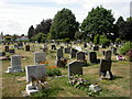
South Stoneham Cemetery
Off Mansbridge Road; gravestones here date from the 1970s.
Image: © Mike Faherty
Taken: 10 Jul 2010
0.07 miles
2
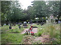
South Stoneham Cemetery, Muslim section
Gravestones are differently aligned from those in the main Christian part, behind the hedge.
Image: © Mike Faherty
Taken: 10 Jul 2010
0.08 miles
3
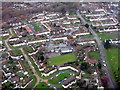
Housing estate at Swaythling
With the A27 running down the RH side of the picture and Mansbridge Primary School in the centre.
Image: © M J Richardson
Taken: 27 Nov 2017
0.11 miles
5
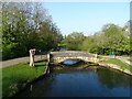
Itchen Way (41)
These are the old and new Mans Bridges.
Image: © Shazz
Taken: 4 Mar 2013
0.13 miles
6
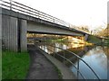
River Itchen: A27 Mansbridge Road bridge
This bridge replaced Image], which is visible in the distance, as the one carrying the A27 road over the river.
Image: © Nigel Cox
Taken: 23 Dec 2015
0.13 miles
7
Swaythling, vehicle storage
New Ford vans in storage at the old reservoir site.
Image: © Mike Faherty
Taken: 10 Jul 2010
0.13 miles
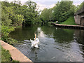
10
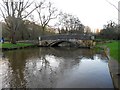
River Itchen: Mans Bridge
Mans Bridge is a Grade II Listed Structure and the Historic England website describes it thus:-
"Late C18. A single segmental arch of tooled stone 'lamb's wool pattern' with a stringcourse at road level, projecting keystone, and solid balustrade with rounded coping swept out at each end to circular piers crowned with conical, slightly projecting capping."
The bridge once carried the main A27 road over the river, but is now restricted to pedestrian and cycle use.
Image: © Nigel Cox
Taken: 23 Dec 2015
0.14 miles