IMAGES TAKEN NEAR TO
Bond Road, SOUTHAMPTON, SO18 1LP
Introduction
This page details the photographs taken nearby to Bond Road, SO18 1LP by members of the Geograph project.
The Geograph project started in 2005 with the aim of publishing, organising and preserving representative images for every square kilometre of Great Britain, Ireland and the Isle of Man.

There are currently over 7.5m images from over14,400 individuals and you can help contribute to the project by visiting https://www.geograph.org.uk
Image Map
Images are licensed for reuse under creativecommons.org/licenses/by-sa/2.0
Notes
- Clicking on the map will re-center to the selected point.
- The higher the marker number, the further away the image location is from the centre of the postcode.
Image Listing (63 Images Found)
Images are licensed for reuse under creativecommons.org/licenses/by-sa/2.0
Image
Details
Distance
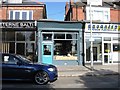
1
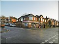
Bitterne Park, London Off-Licence
Corner shop at the junction of Bond and St. Catherines Roads.
Image: © Mike Faherty
Taken: 31 Dec 2016
0.03 miles
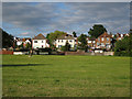
2
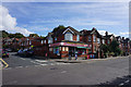
Corner shop on St Catherine's Road
Situated within the large and mature residential area of Bitterne Park.
Image: © Bill Boaden
Taken: 29 Sep 2016
0.04 miles
3
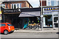
Butcher's Hook
A now renowned micropub in a former butcher's shop. Unfortunately not open until the evening.
Image: © Bill Boaden
Taken: 29 Sep 2016
0.11 miles
4
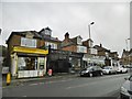
Bitterne Park, Butchers Hook
Southampton's first micro-pub, on Bitterne Triangle, perhaps hiding its light under a bushel - it has the light blue door. Because of limited opening hours, its wares could not be sampled.
Image: © Mike Faherty
Taken: 31 Dec 2016
0.11 miles
5
The Butcher's Hook, Bitterne Triangle
New Alehouse
Image: © Alex McGregor
Taken: 25 May 2014
0.12 miles
7
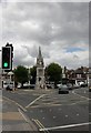
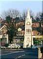
Bitterne Park, clock tower
On Bitterne Park Triangle; according to the plaque, bequeathed by Mrs Henrietta Bellenden Sayers in 1889, "in evidence of her care both for men and beast". Recesses for horse troughs have been filled in, so beasts presumably no longer benefit.
Image: © Mike Faherty
Taken: 17 Jul 2010
0.13 miles
8
Itchen Way (35)
This clock tower is on the route. Another view is at http://www.geograph.org.uk/photo/1967498.
Image: © Shazz
Taken: 4 Mar 2013
0.13 miles
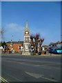
10
Bitterne Triangle
The Sayers Monument is partly obscured by trees. It was both a clock tower and a fountain and was moved here from central Southampton in 1934. Beyond it, one looks down to Cobden Bridge crossing the Itchen.
Image: © Bill Boaden
Taken: 29 Sep 2016
0.13 miles