IMAGES TAKEN NEAR TO
Hillside Avenue, SOUTHAMPTON, SO18 1JY
Introduction
This page details the photographs taken nearby to Hillside Avenue, SO18 1JY by members of the Geograph project.
The Geograph project started in 2005 with the aim of publishing, organising and preserving representative images for every square kilometre of Great Britain, Ireland and the Isle of Man.

There are currently over 7.5m images from over14,400 individuals and you can help contribute to the project by visiting https://www.geograph.org.uk
Image Map (Loading...)


Getting Data...Please wait
Leaflet Map data © OpenStreetMap
Images are licensed for reuse under creativecommons.org/licenses/by-sa/2.0
Notes
- Clicking on the map will re-center to the selected point.
- The higher the marker number, the further away the image location is from the centre of the postcode.
Image Listing (10 Images Found)
Images are licensed for reuse under creativecommons.org/licenses/by-sa/2.0
Image
Details
Distance
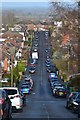
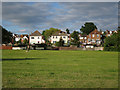
2
Ash Tree Road
A residential road in the long-established residential area of Bitterne Park. It is viewed here near its junction with St Catherine's Road.
Image: © Bill Boaden
Taken: 29 Sep 2016
0.12 miles
3
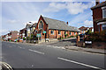
Bitterne Park Baptist Church
Situated in the middle of a large residential area.
Image: © Bill Boaden
Taken: 29 Sep 2016
0.16 miles
4
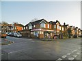
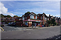
Bitterne Park, London Off-Licence
Corner shop at the junction of Bond and St. Catherines Roads.
Image: © Mike Faherty
Taken: 31 Dec 2016
0.19 miles
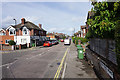
5
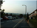
Woodmill Lane, Southampton
Looking North along Woodmill Lane, Townhill Park.
Image: © GaryReggae
Taken: 13 Jul 2005
0.19 miles
6
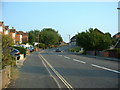
Woodmill Lane, Southampton
Woodmill Lane, looking South up the hill towards The Castle pub.
Image: © GaryReggae
Taken: 13 Jul 2005
0.19 miles
7
Corner shop on St Catherine's Road
Situated within the large and mature residential area of Bitterne Park.
Image: © Bill Boaden
Taken: 29 Sep 2016
0.20 miles
8
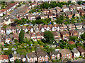
Bitterne Park
Taken from an aircraft on the approach to Southampton Airport.
Image: © David Dixon
Taken: 6 Jul 2016
0.20 miles
10

Bitterne Park School
A secondary school on an extensive site between Dimond and Copsewood Roads: https://en.wikipedia.org/wiki/Bitterne_Park_School (the school website appears to be currently down).
Image: © Mike Faherty
Taken: 31 Dec 2016
0.24 miles