IMAGES TAKEN NEAR TO
Priory Road, SOUTHAMPTON, SO17 2JZ
Introduction
This page details the photographs taken nearby to Priory Road, SO17 2JZ by members of the Geograph project.
The Geograph project started in 2005 with the aim of publishing, organising and preserving representative images for every square kilometre of Great Britain, Ireland and the Isle of Man.

There are currently over 7.5m images from over14,400 individuals and you can help contribute to the project by visiting https://www.geograph.org.uk
Image Map
Images are licensed for reuse under creativecommons.org/licenses/by-sa/2.0
Notes
- Clicking on the map will re-center to the selected point.
- The higher the marker number, the further away the image location is from the centre of the postcode.
Image Listing (115 Images Found)
Images are licensed for reuse under creativecommons.org/licenses/by-sa/2.0
Image
Details
Distance
1
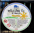
Welcome to St Denys Playarea, Southampton
On the fence here. http://www.geograph.org.uk/photo/5092405 In the interests of all children's health please do not bring pets or alcohol into this area.
Image: © Jaggery
Taken: 24 Aug 2016
0.01 miles
2
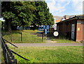
St Denys Play Area, Southampton
At the edge of St Denys Community Centre, set back from Priory Road near the corner of Adelaide Road.
Image: © Jaggery
Taken: 24 Aug 2016
0.01 miles
3
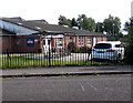
St Denys Community Centre, Southampton
Set back from Priory Road near the corner of Adelaide Road.
Image: © Jaggery
Taken: 24 Aug 2016
0.01 miles
4
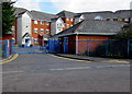
Quay 2000 entrance, Horseshoe Bridge, Southampton
Apartment building on the west bank of the River Itchen.
Image: © Jaggery
Taken: 24 Aug 2016
0.02 miles
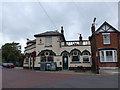
5

No Through Road at The Junction Inn
A local pub near the railway junction at St Denys Station a short way up the road. The sitting out area in front is actually a landscaped road block to close off the end of Adelaide Road to through traffic.
Image: © Des Blenkinsopp
Taken: 23 Aug 2018
0.02 miles

7
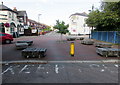
Seating area at the southern end of Adelaide Road, St Denys, Southampton
Viewed from the northern end of the road named Horseshoe Bridge. The Junction Inn http://www.geograph.org.uk/photo/5092093 is on the left.
Image: © Jaggery
Taken: 24 Aug 2016
0.02 miles
9
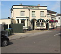
Junction Inn, St Denys, Southampton
Priory Road side of the pub on the corner of Adelaide Road, near St Denys
railway station which is located on the south side of a railway junction.
Image: © Jaggery
Taken: 24 Aug 2016
0.03 miles
10
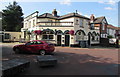
Junction Inn, St Denys, Southampton
Pub on the corner of Priory Road and Adelaide Road, near St Denys
railway station which is located on the south side of a railway junction.
http://www.geograph.org.uk/photo/5092096 to the name sign.
Image: © Jaggery
Taken: 24 Aug 2016
0.03 miles