IMAGES TAKEN NEAR TO
Shutler Close, SO16 8NR
Introduction
This page details the photographs taken nearby to Shutler Close, SO16 8NR by members of the Geograph project.
The Geograph project started in 2005 with the aim of publishing, organising and preserving representative images for every square kilometre of Great Britain, Ireland and the Isle of Man.

There are currently over 7.5m images from over14,400 individuals and you can help contribute to the project by visiting https://www.geograph.org.uk
Image Map
Images are licensed for reuse under creativecommons.org/licenses/by-sa/2.0
Notes
- Clicking on the map will re-center to the selected point.
- The higher the marker number, the further away the image location is from the centre of the postcode.
Image Listing (5 Images Found)
Images are licensed for reuse under creativecommons.org/licenses/by-sa/2.0
Image
Details
Distance
1
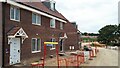
New homes under construction, Harrison Way, Rownhams
Part of the Broadleaf Park development.
Image: © David Martin
Taken: 4 Sep 2022
0.06 miles
2
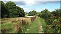
Footpath south of Routs Copse
This path runs along a small valley to the north of a new housing development, starting at the point where Image was taken.
Image: © David Martin
Taken: 4 Sep 2022
0.23 miles
3
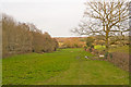
Footpath north of Parker's Farm, Rownhams
Routs Copse is on the left. The other side of the copse is the southern part of Rownhams motorway service area.
Image: © Peter Facey
Taken: 15 Mar 2009
0.24 miles
4
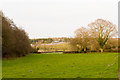
Footpath south of Routs Copse, Rownhams
With M27 motorway in background.
Image: © Peter Facey
Taken: 15 Mar 2009
0.24 miles
5
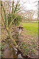
Tanner's Brook
The brook runs along the SW edge of Dymer's Wood and is seen from a footbridge taking the footpath into Dymer's Wood. On the right are fields belonging, I presume, to Parker's Farm.
Image: © Peter Facey
Taken: 15 Mar 2009
0.25 miles