IMAGES TAKEN NEAR TO
Sheldrake Gardens, SOUTHAMPTON, SO16 8HS
Introduction
This page details the photographs taken nearby to Sheldrake Gardens, SO16 8HS by members of the Geograph project.
The Geograph project started in 2005 with the aim of publishing, organising and preserving representative images for every square kilometre of Great Britain, Ireland and the Isle of Man.

There are currently over 7.5m images from over14,400 individuals and you can help contribute to the project by visiting https://www.geograph.org.uk
Image Map
Images are licensed for reuse under creativecommons.org/licenses/by-sa/2.0
Notes
- Clicking on the map will re-center to the selected point.
- The higher the marker number, the further away the image location is from the centre of the postcode.
Image Listing (21 Images Found)
Images are licensed for reuse under creativecommons.org/licenses/by-sa/2.0
Image
Details
Distance
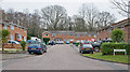
1
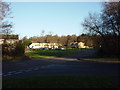
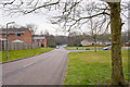
Sandpiper Road estate, Lordshill
This square is dominated by the Sandpiper Road housing estate, constructed in the 1970s. In the background is Lord's Wood itself, a large wooded area extending all the way up to Chilworth.
Image: © GaryReggae
Taken: 29 Jan 2006
0.02 miles
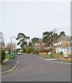
2
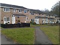
Houses in Sheldrake Gardens
These houses face onto a small green, the other side of which (behind the photographer) is Oakwood Junior School. The rears of the houses face onto the access road, which is a common feature in the Lordswood estate.
Image: © David Martin
Taken: 9 Mar 2013
0.03 miles
3
Oakwood Infant and Junior Schools, Lordswood
See http://www.oakwood-inf.southampton.sch.uk/ and http://www.oakwood-jun.southampton.sch.uk/
Image: © Peter Facey
Taken: 11 Mar 2009
0.08 miles
4
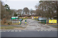
Sandpiper Road approaching the Oakwood schools
With Curlew Close on the left. Oakwood Junior and Infants Schools seem to have a yellow theme, as shown by the pedestrian barriers. The little girl is inanimate.
Image: © Peter Facey
Taken: 11 Mar 2009
0.10 miles
5
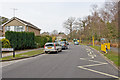
Woburn Road, Lordswood
With Sandpiper Road being the turning on the right. The latter runs in a big circle and provides access to this large housing estate. (The grid line runs along the righthand carriageway of Woburn Road.)
Image: © Peter Facey
Taken: 11 Mar 2009
0.11 miles
6
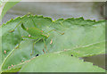
Speckled Bush Cricket
Chilling on a sunflower leaf in Curlew Close, Southampton.
Image: © Jess Smirthwaite
Taken: 31 Jul 2016
0.12 miles
7
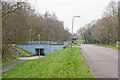
Bridge on Oakwood Drive
The blue bridge carries Oakwood Drive over the pedestrian path. Road on right is Woburn Road.
Image: © Peter Facey
Taken: 11 Mar 2009
0.14 miles
8
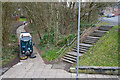
Pedestrian routes under Oakwood Drive
The steps and sloping path lead from Oakwood Drive to the lower level of the path in the foreground which then passes underneath Oakwood Drive, see Image
Image: © Peter Facey
Taken: 11 Mar 2009
0.14 miles
9
Tintagel Close, Lordswood
A residential cul de sac south of Lord's Wood. I entered this because I got fed up with walking along the wet and muddy bridleway within the wood.
Image: © Peter Facey
Taken: 11 Mar 2009
0.14 miles
10
Plover Close, Lordswood
Looking across Sandpiper Road.
Image: © Peter Facey
Taken: 11 Mar 2009
0.15 miles