IMAGES TAKEN NEAR TO
Burgess Road, SOUTHAMPTON, SO16 7AP
Introduction
This page details the photographs taken nearby to Burgess Road, SO16 7AP by members of the Geograph project.
The Geograph project started in 2005 with the aim of publishing, organising and preserving representative images for every square kilometre of Great Britain, Ireland and the Isle of Man.

There are currently over 7.5m images from over14,400 individuals and you can help contribute to the project by visiting https://www.geograph.org.uk
Image Map
Images are licensed for reuse under creativecommons.org/licenses/by-sa/2.0
Notes
- Clicking on the map will re-center to the selected point.
- The higher the marker number, the further away the image location is from the centre of the postcode.
Image Listing (80 Images Found)
Images are licensed for reuse under creativecommons.org/licenses/by-sa/2.0
Image
Details
Distance
3
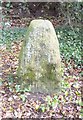
Old Boundary Marker by the A35, Burgess Road
Municipal Boundary Marker - Rosemary Stone, by the A35, in parish of Southampton (Southampton District), Burgess Road, between the junctions with Hill Lane and Burgess Gardens, overlooking ditch and embankment, South side of road.
Southampton HER.
HER Number: MSH201 https://www.heritagegateway.org.uk/Gateway/Results_Single.aspx?uid=MSH201&resourceID=1016
Surveyed
Milestone Society National ID: HA_SOUCOM01pb
Image: © Milestone Society
Taken: Unknown
0.03 miles
4
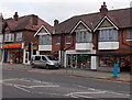
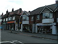
Uptons of Bassett, Southampton
Uptons of Bassett on the right is a butchers shop at 351 Winchester Road.
Bassett Chicken & Pizza is on the left.
Image: © Jaggery
Taken: 16 Nov 2013
0.03 miles
5

The Rosemary Stone, Burgess Road
The medieval town boundaries extended well outside the walls. The burgesses controlled an area enclosed by Hill Lane, Burgess Street (now Burgess Road) and the land west of the River Itchen. The limits of the old town were marked by boundary stones, some of which still survive like the Rosemary Stone seen here. It is on the northern edge of Southampton Common, opposite 47 Burgess Road.
Image: © Jim Champion
Taken: 7 May 2009
0.04 miles
6
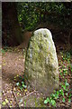
The Rosemary Stone, Burgess Road
The medieval town boundaries extended well outside the walls. The burgesses controlled an area enclosed by Hill Lane, Burgess Street (now Burgess Road) and the land west of the River Itchen. The limits of the old town were marked by boundary stones, some of which still survive like the Rosemary Stone seen here. It is on the northern edge of Southampton Common, opposite 47 Burgess Road. The earth bank in the background is part of the surviving boundary of the Common.
Image: © Jim Champion
Taken: 8 May 2009
0.04 miles
7
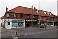
Sunak Pharmacy, Southampton
Located at 19 Burgess Road.
Image: © Jaggery
Taken: 16 Nov 2013
0.04 miles
8
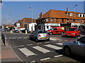
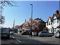
Junction of Hill Lane and Burgess Road
This mini-roundabout is at the junction of Hill Lane and Burgess Road. The pedestrian crossing in the foreground leads across Hill Lane to the north-west corner of Southampton Common.
Image: © Jim Champion
Taken: 27 Sep 2008
0.04 miles