IMAGES TAKEN NEAR TO
Burgess Road, SOUTHAMPTON, SO16 7AB
Introduction
This page details the photographs taken nearby to Burgess Road, SO16 7AB by members of the Geograph project.
The Geograph project started in 2005 with the aim of publishing, organising and preserving representative images for every square kilometre of Great Britain, Ireland and the Isle of Man.

There are currently over 7.5m images from over14,400 individuals and you can help contribute to the project by visiting https://www.geograph.org.uk
Image Map
Images are licensed for reuse under creativecommons.org/licenses/by-sa/2.0
Notes
- Clicking on the map will re-center to the selected point.
- The higher the marker number, the further away the image location is from the centre of the postcode.
Image Listing (39 Images Found)
Images are licensed for reuse under creativecommons.org/licenses/by-sa/2.0
Image
Details
Distance
3
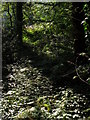
Undergrowth, Southampton Common
Looking south from the path that runs along the northern edge of the common, just to the north-east of the covered reservoir. The canopy is of oak, beech and yew.
Image: © Jim Champion
Taken: 27 Sep 2008
0.06 miles
4
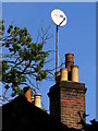
Chimney pots and satellite dish, Burgess Road
This is the rooftop furniture of a house on the south side of Burgess Road. It backs onto the northern edge of Southampton Common, and the 'shadow' of the tall beech and oak trees require this satellite dish to be mounted on a lofty pole.
Image: © Jim Champion
Taken: 27 Sep 2008
0.07 miles
5
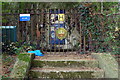
Covered reservoir gate, Southampton Common
There is a covered reservoir in the northern part of Southampton Common, surrounded by iron railings. These steps lead up to the padlocked gate in these railings. The insignia on the gate says 'Southampton Waterworks'. The reservoir is managed by Southern Water and has a capacity of 33,413,100 litres.
Image: © Jim Champion
Taken: 27 Sep 2008
0.07 miles
6

Southampton Common, reservoir
At the northern end of the common, shielded by fir trees; succeeding reservoirs originally built in 1850.
Image: © Mike Faherty
Taken: 21 Apr 2012
0.08 miles
7
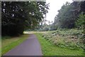
Path onto Southampton Common
Path near to Bassett Avenue/Burgess Road over Southampton Common.
Image: © DS Pugh
Taken: 25 Aug 2016
0.08 miles
8

Path leading to Burgess Road
Looking along a path on Southampton Common leading to the junction of Bassett Avenue and Burgess Road.
Image: © DS Pugh
Taken: 25 Aug 2016
0.09 miles
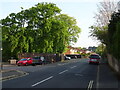
10

Bassett, Sunrise Senior Living
Retirement homes at the corner of Burgess and Butterfield Roads. http://www.sunrise-care.co.uk/community/bassett
Image: © Mike Faherty
Taken: 21 Apr 2012
0.10 miles