IMAGES TAKEN NEAR TO
Dale Road, SOUTHAMPTON, SO16 6QG
Introduction
This page details the photographs taken nearby to Dale Road, SO16 6QG by members of the Geograph project.
The Geograph project started in 2005 with the aim of publishing, organising and preserving representative images for every square kilometre of Great Britain, Ireland and the Isle of Man.

There are currently over 7.5m images from over14,400 individuals and you can help contribute to the project by visiting https://www.geograph.org.uk
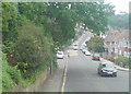
Image Map
Images are licensed for reuse under creativecommons.org/licenses/by-sa/2.0
Notes
- Clicking on the map will re-center to the selected point.
- The higher the marker number, the further away the image location is from the centre of the postcode.
Image Listing (117 Images Found)
Images are licensed for reuse under creativecommons.org/licenses/by-sa/2.0
Image
Details
Distance
1
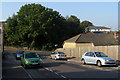
Dale Road, Southampton
Dale Road in Southampton
Image: © Lee
Taken: 16 May 2008
0.01 miles
2
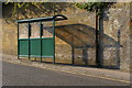
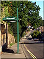
Bus stop shelter, Dale Road
A narrow pavement runs down the west side of Dale Road, and is home to this bus stop shelter.
Image: © Jim Champion
Taken: 28 Sep 2008
0.02 miles
3
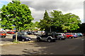
The Range car park
This is the western part of the car park for The Range, off Winchester Road. The spaces are not particularly generous.
Image: © Jim Champion
Taken: 8 May 2009
0.02 miles
4
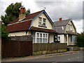
Houses on Dale Road
These two houses are the southernmost on the west side of Dale Road (nearest to the traffic light junction with Winchester Road). They are of an unusual architectural style, not seen elsewhere in this part of the city. The pavement outside the houses is almost impractically narrow.
Image: © Jim Champion
Taken: 4 May 2009
0.03 miles
5
Norham Avenue, Upper Shirley
The western end of Norham Avenue, which drops down to the junction with Dale Road.
Image: © Jim Champion
Taken: 28 Sep 2008
0.03 miles
6
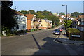
Dale Road, Shirley
View along Dale Road from the western end of Norham Avenue. Buildings at Southampton General Hospital are visible in the distance - ambulances headed for the accident and emergency department are frequently seen (and heard) on this road.
Image: © Jim Champion
Taken: 28 Sep 2008
0.04 miles
7
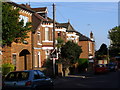
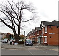
St Winifred's Road, Shirley
The houses on the left are on the north-east side of St Winifred's Road. The junction with Winchester Road is blocked off to vehicles, access is via Vinery Road and St James' Park Road. On the far left is Brandon House.
Image: © Jim Champion
Taken: 21 Apr 2009
0.04 miles
8

St Winifred's Road, Southampton
Viewed from the Winchester Road end looking towards Vinery Road.
Image: © Jaggery
Taken: 16 Nov 2013
0.04 miles
9
Dale Road, Shirley
Looking down Dale Road towards the mini-roundabout at the junction with Dale Valley Road. Bus stop on the left in the foreground.
Image: © Jim Champion
Taken: 13 Sep 2009
0.05 miles
10
Christopher Carter veterinary surgery, Southampton
The veterinary surgery is at 224 Winchester Road. Out of shot on the right is a Range store. http://www.geograph.org.uk/photo/3785649
Image: © Jaggery
Taken: 16 Nov 2013
0.05 miles