IMAGES TAKEN NEAR TO
Warren Avenue, SOUTHAMPTON, SO16 6AF
Introduction
This page details the photographs taken nearby to Warren Avenue, SO16 6AF by members of the Geograph project.
The Geograph project started in 2005 with the aim of publishing, organising and preserving representative images for every square kilometre of Great Britain, Ireland and the Isle of Man.

There are currently over 7.5m images from over14,400 individuals and you can help contribute to the project by visiting https://www.geograph.org.uk
Image Map
Images are licensed for reuse under creativecommons.org/licenses/by-sa/2.0
Notes
- Clicking on the map will re-center to the selected point.
- The higher the marker number, the further away the image location is from the centre of the postcode.
Image Listing (26 Images Found)
Images are licensed for reuse under creativecommons.org/licenses/by-sa/2.0
Image
Details
Distance
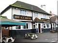
3
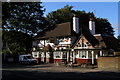
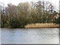
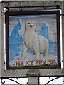
The Ice House, Warren Avenue
Pub on the west side of Warren Avenue, close to the 'Ice House' pond, also known as Shirley Pond.
Image: © Jim Champion
Taken: 13 Sep 2009
0.14 miles
6
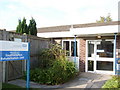
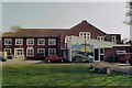
Victoria House, Southampton Rehabilitation Unit
Words cannot describe what a genuinely incredible place this is - with expert and dedicated staff, determined to ensure that everyone gets the chance to make the best of themselves that they can.
Image: © Val Pollard
Taken: 4 Nov 2007
0.17 miles
7
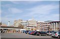
Southampton General Hospital
The hospital and Victoria House (Southampton Rehabilitation Unit) from the Tremona Road entrance.
Image: © Val Pollard
Taken: 4 Nov 2007
0.17 miles
8
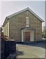
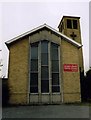
Poor Clare Monastery of the Sacred Heart, Old Shirley
Convent Chapel.
Image: © Michael FORD
Taken: Unknown
0.18 miles
9
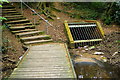
End of the Holly Brook board-walk
This is the downstream end of the Holly Brook board-walk, where the path leads up steps to the recreation ground and the stream enters a tunnel beneath the recreation ground. All part of the Lordsdale Greenway.
Image: © Jim Champion
Taken: 4 May 2009
0.18 miles