IMAGES TAKEN NEAR TO
Mill Lane, SOUTHAMPTON, SO16 0YE
Introduction
This page details the photographs taken nearby to Mill Lane, SO16 0YE by members of the Geograph project.
The Geograph project started in 2005 with the aim of publishing, organising and preserving representative images for every square kilometre of Great Britain, Ireland and the Isle of Man.

There are currently over 7.5m images from over14,400 individuals and you can help contribute to the project by visiting https://www.geograph.org.uk
Image Map
Images are licensed for reuse under creativecommons.org/licenses/by-sa/2.0
Notes
- Clicking on the map will re-center to the selected point.
- The higher the marker number, the further away the image location is from the centre of the postcode.
Image Listing (21 Images Found)
Images are licensed for reuse under creativecommons.org/licenses/by-sa/2.0
Image
Details
Distance
1
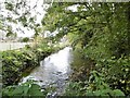
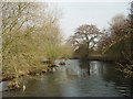
Nursling, River Test
Looking upstream from Conagar Bridge at one of the two river branches.
Image: © Mike Faherty
Taken: 19 Oct 2015
0.02 miles
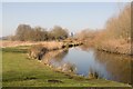
2
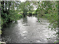
River Test from Conagar Bridge
This bridge carries Mill Lane which, as its name suggests, is a cul-de-sac terminating at Nursling Mill.
Image: © Stuart Logan
Taken: 5 Oct 2012
0.04 miles
3
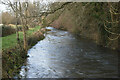
One of several channels of the River Test, north of Mill Lane
Image: © David Martin
Taken: 26 Jan 2023
0.04 miles
4
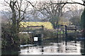
Sluices on a channel of the River Test, seen from Mill Lane
Image: © David Martin
Taken: 22 Jan 2017
0.04 miles
5
River Test, near Nursling Mill
The River Test, where it crosses Mill Lane near Nursling.
Image: © GaryReggae
Taken: 5 Feb 2006
0.05 miles
6
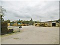
Nursling, New Forest Fencing
Fencing business on Mill Lane: http://www.newforestfencing.co.uk/supply-only/about-us/what-we-can-do-for-you/
Image: © Mike Faherty
Taken: 19 Oct 2015
0.08 miles
7
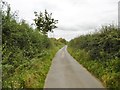
Nursling, Mill Lane
Heading towards Nursling Mill.
Image: © Mike Faherty
Taken: 19 Oct 2015
0.10 miles
8
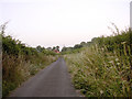
Mill Lane, Nursling
From the end of this lane at Nursling Mill there is a footpath across the millstream and the Testwood lakes, although there doesn't seem to be a good place to park. Maybe best approached from the Totton side, rather than the Nursling side.
Image: © Jim Champion
Taken: 12 Jul 2005
0.19 miles
9
Broadlands Lake, Nursling
This is a small lake east of the main one. IT is in an oval shaped lake with a central island, turning the water almost into a figure 8. See also Image
Image: © Peter Facey
Taken: 19 Feb 2008
0.20 miles
10
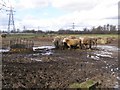
Muddy cows north of Manor House Farm, Nursling
Looking across this field from the stile on Mill Lane. The OS map I have describes this field as a 'gravel tip' - presumably that was prior to its current use as a field for cattle.
Image: © Jim Champion
Taken: 21 Feb 2007
0.21 miles