IMAGES TAKEN NEAR TO
Andes Road, SOUTHAMPTON, SO16 0AG
Introduction
This page details the photographs taken nearby to Andes Road, SO16 0AG by members of the Geograph project.
The Geograph project started in 2005 with the aim of publishing, organising and preserving representative images for every square kilometre of Great Britain, Ireland and the Isle of Man.

There are currently over 7.5m images from over14,400 individuals and you can help contribute to the project by visiting https://www.geograph.org.uk
Image Map
Images are licensed for reuse under creativecommons.org/licenses/by-sa/2.0
Notes
- Clicking on the map will re-center to the selected point.
- The higher the marker number, the further away the image location is from the centre of the postcode.
Image Listing (58 Images Found)
Images are licensed for reuse under creativecommons.org/licenses/by-sa/2.0
Image
Details
Distance
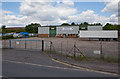
1
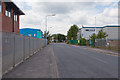
Commercial Premises on Andes Road, Nursling
Scania on the right.
Image: © Peter Facey
Taken: 25 Jul 2010
0.03 miles
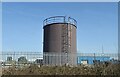
3
Total Butler premises, Andes Road, Nursling
The company supplies oil.
Image: © Peter Facey
Taken: 25 Jul 2010
0.04 miles
4
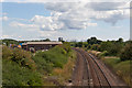
Railway looking south from Weston Lane bridge
The next station is Totton. The premises on the left are those of Butler Total.
Image: © Peter Facey
Taken: 25 Jul 2010
0.06 miles
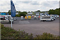
5
Marshall Fleet Solutions, Andes Road, Nursling
(elevated camera position)
Image: © Peter Facey
Taken: 25 Jul 2010
0.08 miles
6
Remains of old road to Nursling Mill
This road, shown on the historical map is now marooned between units in Nursling Industrial Park. The traffic now follows the newer Andes Road.
Image: © Peter Facey
Taken: 25 Jul 2010
0.09 miles
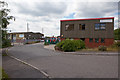
8
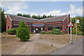
Offices of CiM Services, Nursling Industrial Park
On the left as you enter the park.
Image: © Peter Facey
Taken: 25 Jul 2010
0.11 miles
9
Andes Road, Nursling
Approaching the narrow bridge over the railway. This is controlled by the traffic lights shown.
Image: © Peter Facey
Taken: 25 Jul 2010
0.11 miles
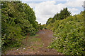
10

Path on edge of Lower Test Nature Reserve
The Southampton-Salisbury railway line runs behind the hedge on the right.
Image: © David Martin
Taken: 6 Oct 2023
0.12 miles