IMAGES TAKEN NEAR TO
Morland Road, SOUTHAMPTON, SO15 5JX
Introduction
This page details the photographs taken nearby to Morland Road, SO15 5JX by members of the Geograph project.
The Geograph project started in 2005 with the aim of publishing, organising and preserving representative images for every square kilometre of Great Britain, Ireland and the Isle of Man.

There are currently over 7.5m images from over14,400 individuals and you can help contribute to the project by visiting https://www.geograph.org.uk
Image Map
Images are licensed for reuse under creativecommons.org/licenses/by-sa/2.0
Notes
- Clicking on the map will re-center to the selected point.
- The higher the marker number, the further away the image location is from the centre of the postcode.
Image Listing (130 Images Found)
Images are licensed for reuse under creativecommons.org/licenses/by-sa/2.0
Image
Details
Distance
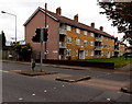
1
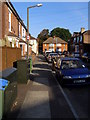
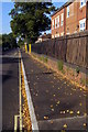
Pavement, Morland Road, Shirley
Looking north along the pavement on the west side of Morland Road. The 20mph sign on the lamp-post is a recent addition, a result of this area around the junior school being designated a 20mph zone. At the end of the road is the junction with Shayer Road.
Image: © Jim Champion
Taken: 21 Sep 2008
0.02 miles
2
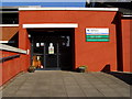
Entrance to Shirley Junior School
The modern entrance to Shirley Junior School, off Bellemoor Road.
Image: © Jim Champion
Taken: 21 Sep 2008
0.04 miles
3
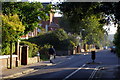
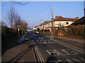
Bellemoor Road, Shirley
From the junction at St James Road to here, Bellemoor Road is one-way only for motor vehicles, with a contraflow cycle lane. The turning on the left is Morland Road, leading to Shayer Road. Bellemoor Road continues on past Shirley Junior and Infant School towards the Common.
Image: © Jim Champion
Taken: 21 Sep 2008
0.04 miles
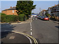
4
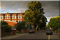
Bellemoor Road, Shirley
Looking north-east along Bellemoor Road from the junction with Morland Road. The building on the left illuminated by evening sunlight is Shirley Junior School, a non-denominational mixed junior (7-11) school maintained by the Southampton City Council Education Authority (according to their 2008 prospectus).
Image: © Jim Champion
Taken: 19 Jul 2008
0.04 miles
5
Pavement outside Shirley Junior School, Bellemoor Road
This pavement outside Shirley Junior School was widened and improved during August 2008.
Image: © Jim Champion
Taken: 21 Sep 2008
0.04 miles
6
Wilton Road, Shirley
Looking along Wilton Road from the junction with Bellemoor Road, towards Winchester Road. Only buses and taxis may continue up this part of the road, presumably to stop 'rat running' by private vehicles. Shirley Junior School is on the left. There is still some frost remaining in the shadows.
Image: © Jim Champion
Taken: 20 Dec 2007
0.06 miles
7
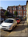
Queens Road, Shirley
View towards the junction of Queens Road and Wilton Road, with the Shirley infant school building in the background.
Image: © Jim Champion
Taken: 28 Sep 2008
0.06 miles
8
Wilton Road, Southampton
Viewed across the A35 Winchester Road. The blue sign on the left shows
'Buses and cycles only 165 yards ahead'. Other signs show a 20mph maximum speed zone.
Image: © Jaggery
Taken: 16 Nov 2013
0.06 miles
9
St James Close, Southampton
Flats viewed across Winchester Road.
Image: © Jaggery
Taken: 16 Nov 2013
0.06 miles
10
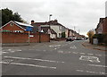
Wilton Road, Shirley
Looking north up Wilton Road towards the junction with Winchester Road. The blue building in the distance is the side of The Range store. The turning on the left was once the eastern end of Shayer Road, but now only leads to the gate to Shirley Junior School's field.
Image: © Jim Champion
Taken: 28 Sep 2008
0.07 miles