IMAGES TAKEN NEAR TO
Arthur Road, SOUTHAMPTON, SO15 5DU
Introduction
This page details the photographs taken nearby to Arthur Road, SO15 5DU by members of the Geograph project.
The Geograph project started in 2005 with the aim of publishing, organising and preserving representative images for every square kilometre of Great Britain, Ireland and the Isle of Man.

There are currently over 7.5m images from over14,400 individuals and you can help contribute to the project by visiting https://www.geograph.org.uk
Image Map
Images are licensed for reuse under creativecommons.org/licenses/by-sa/2.0
Notes
- Clicking on the map will re-center to the selected point.
- The higher the marker number, the further away the image location is from the centre of the postcode.
Image Listing (85 Images Found)
Images are licensed for reuse under creativecommons.org/licenses/by-sa/2.0
Image
Details
Distance
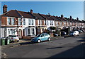
1
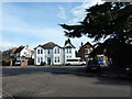
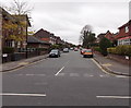
An autumnal anti-clockwise stroll (41)
Looking across Suffolk Avenue towards Arthur Road.
Image: © Basher Eyre
Taken: 30 Oct 2012
0.03 miles
2
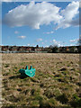
The Field
View of a small part of The 8 Acre Sports Field behind St Marks School, Shirley Road, Freemantle, Southampton. See more pictures on www.CommunityHub.info and www.Festival.Vibert.co.uk. It's a HUGE Sports and Playing field, currently in 2010 locked-up to the public, and is not visible from the road.
Image: © Cevn Vibert
Taken: Unknown
0.06 miles
3
An autumnal anti-clockwise stroll (40)
Looking from Charlton Road into Suffolk Avenue.
Image: © Basher Eyre
Taken: 30 Oct 2012
0.06 miles
4
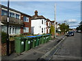
An autumnal anti-clockwise stroll (42)
A parade of wheelie bins in Suffolk Avenue
Image: © Basher Eyre
Taken: 30 Oct 2012
0.06 miles
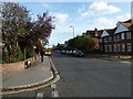
5
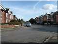
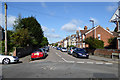
Darwin Road, Southampton
Looking west from Hill Lane.
Image: © Jaggery
Taken: 16 Nov 2013
0.08 miles
6
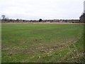
Unexpected green space: the ex-Civil Service Sports Ground
This field provides a large open space behind St Mark's School and served many years until 1999 as a Civil Service Sports Ground. At the date of this photograph, there is no public access.
Image: © David Martin
Taken: 13 Feb 2010
0.09 miles
7
An autumnal anti-clockwise stroll (39)
Mid section of Charlton Road
Image: © Basher Eyre
Taken: 30 Oct 2012
0.10 miles
9
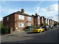
Stafford Road houses, Southampton
Viewed from the school http://www.geograph.org.uk/photo/3762992 end of Stafford Road.
Image: © Jaggery
Taken: 16 Nov 2013
0.13 miles
10
An autumnal anti-clockwise stroll (43)
Junction of Suffolk Avenue and Howard Road
Image: © Basher Eyre
Taken: 30 Oct 2012
0.13 miles