IMAGES TAKEN NEAR TO
New Town, MARLBOROUGH, SN8 4LU
Introduction
This page details the photographs taken nearby to New Town, SN8 4LU by members of the Geograph project.
The Geograph project started in 2005 with the aim of publishing, organising and preserving representative images for every square kilometre of Great Britain, Ireland and the Isle of Man.

There are currently over 7.5m images from over14,400 individuals and you can help contribute to the project by visiting https://www.geograph.org.uk
Image Map
Images are licensed for reuse under creativecommons.org/licenses/by-sa/2.0
Notes
- Clicking on the map will re-center to the selected point.
- The higher the marker number, the further away the image location is from the centre of the postcode.
Image Listing (12 Images Found)
Images are licensed for reuse under creativecommons.org/licenses/by-sa/2.0
Image
Details
Distance
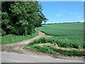
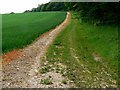
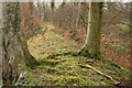
3
Wansdyke crosses un-named road by South Lodge
The line of trees delineate the 5th or 6th C. East Wansdyke; an impressive linear earthwork, consisting of a ditch and bank running approximately east-west, between Savernake Forest and Morgan's Hill. For more detail see:
http://en.wikipedia.org/wiki/Wansdyke_(earthwork)
Image: © Stuart Logan
Taken: 29 Mar 2013
0.04 miles
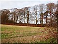
4
Wansdyke, near East Kennett
The old earthwork from Bath to Savernake is private along the stretch visible here. There is a Wansdyke path a little further south.
Image: © Brian Robert Marshall
Taken: 6 Jun 2008
0.04 miles
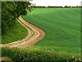
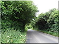
5
Wansdyke, near East Kennett
This stretch of the Wansdyke is shown as a footpath. Further on it becomes a bridleway. The Wansdyke is an ancient earthwork that led from Bath to Savernake.
Image: © Brian Robert Marshall
Taken: 6 Jun 2008
0.09 miles
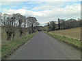
7
National Cycle Route 45 towards Alton Barnes
Image: © JThomas
Taken: 13 Jul 2019
0.09 miles
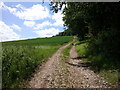
9
Path on Wansdyke
From Furze Hill down to the road Wansdyke is somewhat overgrown although this is a relatively open section. At this point the right of way seems to run along the top of the bank although it seems that many people use the edge of the field at the base of the bank.
Image: © Doug Lee
Taken: 10 Apr 2010
0.13 miles
10
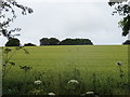
Hillside cereal crop beside National Cycle Route 45
Image: © JThomas
Taken: 13 Jul 2019
0.14 miles