IMAGES TAKEN NEAR TO
Hilldrop Close, MARLBOROUGH, SN8 2RA
Introduction
This page details the photographs taken nearby to Hilldrop Close, SN8 2RA by members of the Geograph project.
The Geograph project started in 2005 with the aim of publishing, organising and preserving representative images for every square kilometre of Great Britain, Ireland and the Isle of Man.

There are currently over 7.5m images from over14,400 individuals and you can help contribute to the project by visiting https://www.geograph.org.uk
Image Map
Images are licensed for reuse under creativecommons.org/licenses/by-sa/2.0
Notes
- Clicking on the map will re-center to the selected point.
- The higher the marker number, the further away the image location is from the centre of the postcode.
Image Listing (130 Images Found)
Images are licensed for reuse under creativecommons.org/licenses/by-sa/2.0
Image
Details
Distance
1
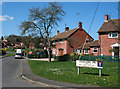
Knowledge Crescent
An ordinary street off Back Lane in Ramsbury. I just thought it was an unusual name.
Tried to find some explanation for it on Google, but gave up after several pages of house prices.
Someone from the British Goat Society lives there if that's any help.
Anyway, Knowledge Crescent, leads to Hilldrop Close and Knowledge hill.
Not a lot of people know that.
Image: © Des Blenkinsopp
Taken: 8 Apr 2010
0.07 miles
2
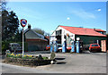
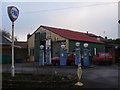
Retro Fina
One for the Logo Historians here.
Ignore the red cars, but check the VW Beetle and Morris Minor just visible.
When would you say this scene last changed substantially? Early 70's? It's the plastic sign on the pole makes me guess that. The pumps look older.
This is Laurel Garage, which has survived the decades and is still in business in Back Lane, Ramsbury.
Image: © Des Blenkinsopp
Taken: 8 Apr 2010
0.08 miles
3
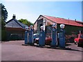
Laurel Garage, Ramsbury
A step back to a different motoring age at Laurel Garage with its ancient Fina pumps and garage interior which looks like something out of the 1950's. The garage is run by Bernard White, son of Jim 'Chalky' White who sold me my first car in 1963. [a 1955 Standard 8] Jim White was known for his fondness of the Austin Atlantic convertible, of which he once had a substantial collection. None were visible on this occasion.
Image: © Gordon Hatton
Taken: 3 Jun 2010
0.09 miles
4
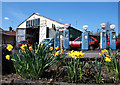
Laurel Garage
Just a close up with flowers of probably the oldest working petrol pumps in the land.http://www.gazetteandherald.co.uk/news/towns/marlboroughheadlines/4735034.Ramsbury_pumps_go_the_distance/
For another view see Image
Image: © Des Blenkinsopp
Taken: 8 Apr 2010
0.09 miles
5
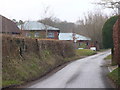
Hilldrop Lane, Ramsbury
Narrow lane leading north from the main road through Ramsbury village. It is close to the recreation centre.
www.ramsbury.org
Image: © Colin Smith
Taken: 1 Feb 2011
0.10 miles
6
The Laurels Garage, Ramsbury
Eye-catching scene on Back Lane, Ramsbury. The vintage Fina petrol pumps are more than 50 years old and still in use. Petrol was 3 shillings a gallon in 1950! The Fina sign looks to be just as old.
www.ramsbury.org
Image: © Colin Smith
Taken: 1 Feb 2011
0.10 miles
7
![Ramsbury houses [28]](https://s2.geograph.org.uk/geophotos/06/44/74/6447450_9a8e3ad4_120x120.jpg)
Ramsbury houses [28]
Bland modern houses in Lawrence Mead off Back Lane.
Ramsbury lies in fertile farming land in the valley of the River Kennet. The site has been occupied since at least the Iron Age and there are several Roman villas. There was a bishopric of Ramsbury, established by 909 and ended in 1075 when it was included in the bishopric of Salisbury. Until 1744 when the present A4 road was turnpiked, the road through the village was part of the main route from London to Bristol.
Image: © Michael Dibb
Taken: 14 Mar 2020
0.11 miles
8
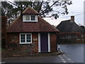
Ramsbury, West End
Small and square red brick cottage at Ramsbury's west end of its attractive High Street.
www.ramsbury.org
Image: © Colin Smith
Taken: 1 Feb 2011
0.11 miles
9
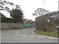
Hilldrop Lane at the junction of Ramsbury High Street
Image: © David Howard
Taken: 24 Apr 2016
0.11 miles
10
![Ramsbury houses [27]](https://s1.geograph.org.uk/geophotos/06/44/74/6447449_579ef0a0_120x120.jpg)
Ramsbury houses [27]
A glimpse of number 84 High Street behind its hedge. A 17th century timber framed and thatched cottage. Listed, grade II, with details at: https://historicengland.org.uk/listing/the-list/list-entry/1183856
Ramsbury lies in fertile farming land in the valley of the River Kennet. The site has been occupied since at least the Iron Age and there are several Roman villas. There was a bishopric of Ramsbury, established by 909 and ended in 1075 when it was included in the bishopric of Salisbury. Until 1744 when the present A4 road was turnpiked, the road through the village was part of the main route from London to Bristol.
Image: © Michael Dibb
Taken: 14 Mar 2020
0.11 miles