IMAGES TAKEN NEAR TO
Mildenhall, MARLBOROUGH, SN8 2NG
Introduction
This page details the photographs taken nearby to SN8 2NG by members of the Geograph project.
The Geograph project started in 2005 with the aim of publishing, organising and preserving representative images for every square kilometre of Great Britain, Ireland and the Isle of Man.

There are currently over 7.5m images from over14,400 individuals and you can help contribute to the project by visiting https://www.geograph.org.uk
Image Map (Loading...)


Getting Data...Please wait
Leaflet Map data © OpenStreetMap
Images are licensed for reuse under creativecommons.org/licenses/by-sa/2.0
Notes
- Clicking on the map will re-center to the selected point.
- The higher the marker number, the further away the image location is from the centre of the postcode.
Image Listing (21 Images Found)
Images are licensed for reuse under creativecommons.org/licenses/by-sa/2.0
Image
Details
Distance
1
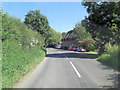
The Axford road southeast of Durnsford Mill Farm
Image: © Stuart Logan
Taken: 24 Jul 2012
0.10 miles
2

The road through Stitchcombe
It starts as White's Hill and ends as something else near Marlborough, but it's unclear what it's called in between.
Image: © David Howard
Taken: 24 Apr 2016
0.14 miles
3
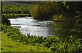
Sun glistening on the River Kennet, Stitchcombe, Wiltshire
This turn in the river has a name - Sheep Drove Bend. The grass in the foreground is a private fishing path; in the distance it is the river's footpath.
Image: © Edmund Shaw
Taken: 18 Apr 2014
0.14 miles
4
River Kennet valley at Stitchcombe (1)
Looking generally in the direction of Mildenhall.
Image: © Nigel Cox
Taken: 12 Jul 2009
0.15 miles
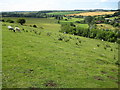
6
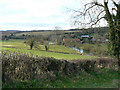
River Kennet and a farm, Stitchcombe
The river can be seen at the right. The farm is either Grove Farm or Durnsford Mill Farm depending on which map you look at.
Image: © Brian Robert Marshall
Taken: 28 Mar 2009
0.15 miles
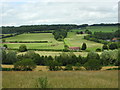
7
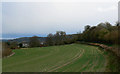
Farmland, Stitchcombe
Stitchcombe Farm can be seen beneath threatening skies on an afternoon that started fine but clouded over before hail started falling.
Image: © Brian Robert Marshall
Taken: 28 Mar 2009
0.16 miles
8
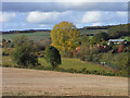
Farmland, Mildenhall
A field of stubble above pasture, the River Kennet and Durnsford Mill Farm.
Image: © Andrew Smith
Taken: 24 Oct 2009
0.18 miles
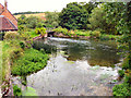
9
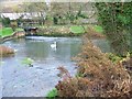
River Kennet, Stitchcombe
Looking upstream from Stitchcombe Bridge.
Image: © Maigheach-gheal
Taken: 22 Nov 2009
0.18 miles
10
Stitchcombe
Stitchcombe, beside the River Kennet
Image: © Chris Collard
Taken: 10 Aug 2005
0.19 miles