IMAGES TAKEN NEAR TO
Rockley, MARLBOROUGH, SN8 1RX
Introduction
This page details the photographs taken nearby to SN8 1RX by members of the Geograph project.
The Geograph project started in 2005 with the aim of publishing, organising and preserving representative images for every square kilometre of Great Britain, Ireland and the Isle of Man.

There are currently over 7.5m images from over14,400 individuals and you can help contribute to the project by visiting https://www.geograph.org.uk
Image Map (Loading...)


Getting Data...Please wait
Leaflet Map data © OpenStreetMap
Images are licensed for reuse under creativecommons.org/licenses/by-sa/2.0
Notes
- Clicking on the map will re-center to the selected point.
- The higher the marker number, the further away the image location is from the centre of the postcode.
Image Listing (9 Images Found)
Images are licensed for reuse under creativecommons.org/licenses/by-sa/2.0
Image
Details
Distance
2
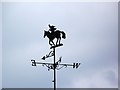
Weather vane, Maizey Farm
For centuries weathervanes have kept people in touch with the elements, signalling those shifts in the wind, which bring changes in the weather. This simple device has grown into an English tradition which can say something about their owners, adding interest to the landscape.
Image: © Maigheach-gheal
Taken: 9 Aug 2009
0.04 miles
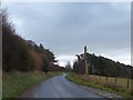
3
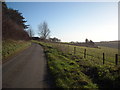
Approaching Maisey Farm, Ogbourne Maizey
Minor road on the approach to Maisey Farm. It would appear that part of the shelter belt of trees to the right of the road has been felled. The farm spells its name with an 's', the village with a 'z'. Elsewhere, it is spelt 'Meysey' Image The name derives from Robert de Maizey, who held the manor from 1242 (perhaps the same Robert de Maizey after whom Marston Meysey is named). http://www.british-history.ac.uk/vch/wilts/vol12/pp138-151
Image: © Vieve Forward
Taken: 2 Jan 2015
0.09 miles
4
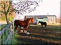
Maisey Farm, Ogbourne Maisey, Marlborough, Wiltshire
The horse in the foreground was evidently enjoying the afternoon sun despite temperatures at freezing point.
Image: © Brian Robert Marshall
Taken: 7 Feb 2007
0.11 miles
5
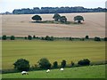
A view south-east from Maisey Farm, near Marlborough
Rough Down lies out of sight on the other side of the hill on the skyline.
Image: © Brian Robert Marshall
Taken: 7 Feb 2007
0.16 miles
6
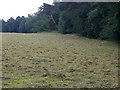
Hay making, Ogbourne Maizey
The grass has been cut and has been left to dry before it is baled.
Image: © Maigheach-gheal
Taken: 9 Aug 2009
0.16 miles
7
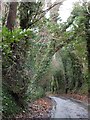
Rockley Road near Maisey Farm
This single track road leads from the farm to Ogbourne Maizey through woodland and drops into the valley of the River Og
Image: © David Smith
Taken: 30 Dec 2013
0.17 miles
8
Sheep grazing, near Ogbourne Maizey
The sheep graze the steep sides of the hill near Maizey Farm.
Image: © Maigheach-gheal
Taken: 9 Aug 2009
0.20 miles
9
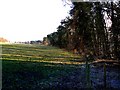
Dead tree and the shelter belt for Maisey Farm
Image: © David Smith
Taken: 30 Dec 2013
0.25 miles