IMAGES TAKEN NEAR TO
Rawlins Park, MARLBOROUGH, SN8 1RQ
Introduction
This page details the photographs taken nearby to Rawlins Park, SN8 1RQ by members of the Geograph project.
The Geograph project started in 2005 with the aim of publishing, organising and preserving representative images for every square kilometre of Great Britain, Ireland and the Isle of Man.

There are currently over 7.5m images from over14,400 individuals and you can help contribute to the project by visiting https://www.geograph.org.uk
Image Map (Loading...)


Getting Data...Please wait
Leaflet Map data © OpenStreetMap
Images are licensed for reuse under creativecommons.org/licenses/by-sa/2.0
Notes
- Clicking on the map will re-center to the selected point.
- The higher the marker number, the further away the image location is from the centre of the postcode.
Image Listing (107 Images Found)
Images are licensed for reuse under creativecommons.org/licenses/by-sa/2.0
Image
Details
Distance
1
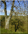
Rawlings Park
A row of trees behind Rawlings Park, near Avebury.
Image: © Wayland Smith
Taken: 27 Nov 2011
0.03 miles
2
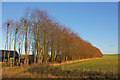
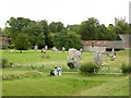
Farm buildings at Rutlands Farm
Seen across the field.
Image: © Oliver Dixon
Taken: 6 Jun 2016
0.08 miles
3
Section of Avebury Stone Circle
This section is of the bottom left hand corner of the square, whereas the rest of avebury is situated in other squares.
Image: © Pam Brophy
Taken: Unknown
0.11 miles
4
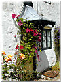
Avebury Doorway with Flowers
This cottage is just down the street from the Avebury stone circle.
Image: © Edie Tepper
Taken: Unknown
0.11 miles
5
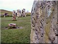
North-west quadrant of Avebury henge
The road to Swindon runs right through the stone circle. The henge's inner ditch can be seen in the foreground and on the right of the picture. The old stone buildings on the right form the "visitor centre" with a cafe and museum and Avebury church tower can be seen peeking above the trees. The megaliths made a convenient source of stone when the houses of the village were built, and many stones were buried (because of their heathen connotations). Many were re-erected during the 20th century.
Image: © Jim Champion
Taken: 15 Aug 2004
0.11 miles
6
Avebury Ring
Ancient monument much more accessible than Stonehenge.
Image: © john spivey
Taken: 18 Feb 2005
0.11 miles

8
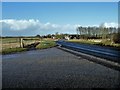
The road to Swindon
The A4361 road across the downs to Swindon. Seen from near the entrance to Avebury Manor.
Image: © Michael Dibb
Taken: 15 Feb 2018
0.15 miles
9
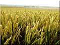
Overlooking wheat fields by Avebury Ring
Image: © Cole Smith
Taken: 24 Jul 2002
0.15 miles