IMAGES TAKEN NEAR TO
Beckhampton, MARLBOROUGH, SN8 1QJ
Introduction
This page details the photographs taken nearby to SN8 1QJ by members of the Geograph project.
The Geograph project started in 2005 with the aim of publishing, organising and preserving representative images for every square kilometre of Great Britain, Ireland and the Isle of Man.

There are currently over 7.5m images from over14,400 individuals and you can help contribute to the project by visiting https://www.geograph.org.uk
Image Map (Loading...)


Getting Data...Please wait
Leaflet Map data © OpenStreetMap
Images are licensed for reuse under creativecommons.org/licenses/by-sa/2.0
Notes
- Clicking on the map will re-center to the selected point.
- The higher the marker number, the further away the image location is from the centre of the postcode.
Image Listing (41 Images Found)
Images are licensed for reuse under creativecommons.org/licenses/by-sa/2.0
Image
Details
Distance
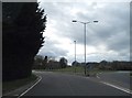
2
A4 heading west
Approaching the A361/A4361 roundabout.
Image: © Robin Webster
Taken: 2 Feb 2018
0.07 miles
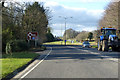
3
The A361 north approaching the A4 at Beckhampton
Image: © Roy Hughes
Taken: 14 Jul 2024
0.07 miles
4
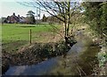
The Beckhampton Bourne
An ephemeral tributary of the Kennet that only appears when groundwater levels are high.
The River Kennet flows west to east for most of its course, but at Avebury the main river changes suddenly to a north - south direction.
This stream here is a continuation of the west-east valley and joins the Kennet just by Silbury Hill.
Image: © Des Blenkinsopp
Taken: 26 Feb 2014
0.08 miles
5
![A circular walk on the Downs from Avebury [13]](https://s0.geograph.org.uk/geophotos/06/47/06/6470692_deca9776_120x120.jpg)
A circular walk on the Downs from Avebury [13]
Butlers Cottage is 17th century in whitewashed sarsen with a thatched roof. There are some later rear extensions. Another view of the cottage is at Image Listed, grade II, with details at: https://historicengland.org.uk/listing/the-list/list-entry/1365947
The walk follows footpaths to Beckhampton and then a byway to Allington Down. A short stretch along Wansdyke before a bridleway and later a byway lead back to West Kennet. A footpath, part of the White Horse Trail, runs around Silbury Hill and back to the start. Just over 7½ miles.
Image: © Michael Dibb
Taken: 16 Apr 2020
0.08 miles
6
![A circular walk on the Downs from Avebury [14]](https://s1.geograph.org.uk/geophotos/06/47/06/6470693_427c3973_120x120.jpg)
A circular walk on the Downs from Avebury [14]
Butlers Cottage is 17th century in whitewashed sarsen with a thatched roof. There are some later rear extensions. Another view of the cottage is at Image Listed, grade II, with details at: https://historicengland.org.uk/listing/the-list/list-entry/1365947
The walk follows footpaths to Beckhampton and then a byway to Allington Down. A short stretch along Wansdyke before a bridleway and later a byway lead back to West Kennet. A footpath, part of the White Horse Trail, runs around Silbury Hill and back to the start. Just over 7½ miles.
Image: © Michael Dibb
Taken: 16 Apr 2020
0.08 miles
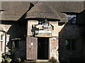
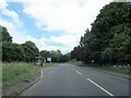
9
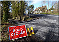
Road Closed at Beckhampton
The lane through the hamlet of Beckhampton has been flooded from the Beckhampton Bourne, an ephemeral stream that flows when groundwater levels are high.
Not a serious flood, and most people round here have 4x4s anyway and plough through regardless.
The Wagon and Horses pub is in the background.
Image: © Des Blenkinsopp
Taken: 26 Feb 2014
0.09 miles
10
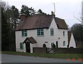
Old Toll House by Marlborough Road, Beckhampton
Beckhampton Toll House (and weigh engine) by the A4, in parish of Avebury (Kennet District), Old Toll House, Marlborough Road, opposite Waggon and Horses PH, SN8 1QJ.
Surveyed
Milestone Society National ID: WI.AVE
Image: © Alan Rosevear
Taken: 9 Mar 2005
0.09 miles