IMAGES TAKEN NEAR TO
Lechlade Road, SWINDON, SN6 7RB
Introduction
This page details the photographs taken nearby to Lechlade Road, SN6 7RB by members of the Geograph project.
The Geograph project started in 2005 with the aim of publishing, organising and preserving representative images for every square kilometre of Great Britain, Ireland and the Isle of Man.

There are currently over 7.5m images from over14,400 individuals and you can help contribute to the project by visiting https://www.geograph.org.uk
Image Map
Images are licensed for reuse under creativecommons.org/licenses/by-sa/2.0
Notes
- Clicking on the map will re-center to the selected point.
- The higher the marker number, the further away the image location is from the centre of the postcode.
Image Listing (25 Images Found)
Images are licensed for reuse under creativecommons.org/licenses/by-sa/2.0
Image
Details
Distance
1
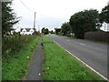
The A361 in Upper Inglesham
Heading for Lechlade and Burford. For about a mile the Thames Path follows the verge of this busy road. There are even signs for motorists warning of 'Walkers ahead: for the next mile the Thames Path National Trail follows this road'. Not that anybody drives any more slowly as a result!
For about ten kilometres between Lechlade and Castle Eaton, the Thames Path passes through some flat and not very interesting country - not helped by the fact that the river itself is visible only for the first kilometre near Lechlade, and later for just 250 metres.
Image: © David Purchase
Taken: 8 Oct 2016
0.03 miles
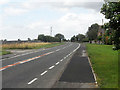
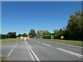
3
A361 at Upper Inglesham
The A361 passing through Upper Inglesham.
Image: © Philip Halling
Taken: 30 Apr 2011
0.06 miles
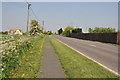
4
A361 towards Lechlade
Leaving Upper Inglesham.
Image: © Robin Webster
Taken: 19 Jan 2020
0.14 miles
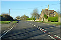
5
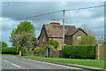
House beside the Lechlade Road at Upper Inglesham
Image: © David Martin
Taken: 25 Apr 2018
0.15 miles
6
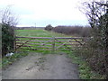
Gate and Field
Off the A361 between Highworth and Lechlade.
Image: © Jonathan Billinger
Taken: 4 Jan 2007
0.16 miles
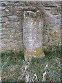
8
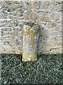
Milestone, Upper Inglesham
On the Western side of the A361, opposite Lynt Farm Lane. Erected by the Swindon, Calne, Cricklade Third District Turnpike Trust in the 19ᵗʰ C.
Milestone Society National ID: WI_SNLC09
Image: © Simon Kosciow
Taken: 22 Jan 2023
0.21 miles
9
Milestone, Upper Inglesham
The milestone reads: "To Lechlade 2 Miles/To Highworth 3 Miles". This milestone is similar in design to some found on the Wootton Bassett to Marlborough Road, see Image] Image] Image]
Image: © Vieve Forward
Taken: 16 Jan 2013
0.22 miles
10
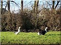
Ducks, Upper Inglesham
Just three of the ducks to be found wandering on the verge of the village street.
Image: © Maigheach-gheal
Taken: 30 Jan 2010
0.22 miles