IMAGES TAKEN NEAR TO
Bath Road, SWINDON, SN6 6DY
Introduction
This page details the photographs taken nearby to Bath Road, SN6 6DY by members of the Geograph project.
The Geograph project started in 2005 with the aim of publishing, organising and preserving representative images for every square kilometre of Great Britain, Ireland and the Isle of Man.

There are currently over 7.5m images from over14,400 individuals and you can help contribute to the project by visiting https://www.geograph.org.uk
Image Map
Images are licensed for reuse under creativecommons.org/licenses/by-sa/2.0
Notes
- Clicking on the map will re-center to the selected point.
- The higher the marker number, the further away the image location is from the centre of the postcode.
Image Listing (422 Images Found)
Images are licensed for reuse under creativecommons.org/licenses/by-sa/2.0
Image
Details
Distance
1
Market cross in Cricklade
The old market cross in Cricklade stands in front of cottages in the corner of the churchyard.
Image: © Philip Halling
Taken: 23 Apr 2011
0.01 miles
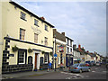
2
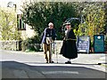
Street scene, Bath Road, Cricklade
Bath Road was probably once a main road link between here and the city that gives it its name. It is a very minor road now. The town of Cricklade is not only the first town on the Thames it also dates to the 9th century. Some of the local dignitaries reflect this in their sartorial inclinations.
Image: © Brian Robert Marshall
Taken: 31 Mar 2017
0.01 miles
3
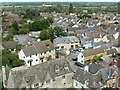
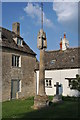
View north-east from St Sampson's tower, Cricklade
The longer view takes in the Upper Thames Valley, the most select part of the Thames Valley as there are no boats. The properties in the foreground are in Bath Road.
Image: © Brian Robert Marshall
Taken: 6 Sep 2009
0.01 miles
4
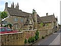
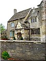
Jenner's School, Bath Road
Robert Jenner, a goldsmith, was Member of Parliament for Cricklade from 1628 to 1648. When he died in 1651, his Will contained an endowment for the purchase of land and the provision of a free school. The result was this building, dating from 1652. At some point the money from the endowment probably ran out, because by 1726 it was decided to turn it into a workhouse for the poor, in effect the destitute. It remained so for over a hundred years, but by between 1834 and 1842, after considerable repair work, it had reverted to use as a school. This use continued until 1959. It is now used as a Parish Hall. This is a summary of the much more detailed information given on the excellent website of Cricklade Museum, run by Cricklade Historical Society.
Some more photos:-
Image
Image
Image
Image: © P L Chadwick
Taken: 26 Sep 2010
0.02 miles
5
Jenner's School, Bath Road
The 17th century former Jenner's School.
Some more photos:- Image
Image: © P L Chadwick
Taken: 26 Sep 2010
0.02 miles
6
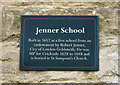
Plaque on Jenner's School, Bath Road
The plaque has been provided by Cricklade Historical Society.
Some more photos:- Image
Image: © P L Chadwick
Taken: 26 Sep 2010
0.02 miles
7
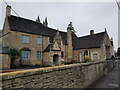
Jenner Hall, Cricklade parish hall
Formerly Jenner's School, on Bath Road. It was built in 1652 and then became a workhouse before reverting to a school again in the 19th century. The rear facing the churchyard can be seen in Image
Image: © Jeff Gogarty
Taken: 16 Oct 2021
0.02 miles
8
Market cross, Cricklade
Cricklade's old market cross stands in the corner of the churchyard of St Sampson's church.
Image: © Philip Halling
Taken: 23 Apr 2011
0.02 miles
9
Cricklade: High Street
This view was taken looking north along the High Street at its junction with the B4040 Calcutt Street. The Vale Hotel was originally the White Horse Inn, and there is a small but fine clock tower at the junction.
Image: © Nigel Cox
Taken: 24 Oct 2006
0.02 miles
10
![Cricklade buildings [23]](https://s2.geograph.org.uk/geophotos/06/34/79/6347942_82f270ec_120x120.jpg)
Cricklade buildings [23]
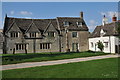
Jenner's School was built in 1652 as a free school, the endowment of Robert Jenner, MP for Cricklade from 1628 to 1648. There is a 19th century extension to the right (not visible in this view) and an 18th century Schoolmaster's house, seen here, has been added on the left. The school is now a community room. Other views of the north fronts of the buildings are at Image and Image The south fronts of the buildings facing the churchyard are at Image
The school is listed, grade II*, with details at: https://historicengland.org.uk/listing/the-list/list-entry/1356089 the Schoolmaster's house is listed, grade II, with details at: https://historicengland.org.uk/listing/the-list/list-entry/1023079
Cricklade is the first town downstream on the River Thames. The town was founded by the Anglo-Saxons in the 9th century at the point where the Roman Ermin Way crosses the River Thames. It is one of the thirty burhs (fortified towns) recorded in the Burghal Hidage document, which describes a system of fortresses and fortified towns built around Wessex by King Alfred. The fortifications have been extensively excavated in several places on all four of its sides.
Image: © Michael Dibb
Taken: 25 Aug 2019
0.02 miles