IMAGES TAKEN NEAR TO
Fair View, SWINDON, SN6 6BE
Introduction
This page details the photographs taken nearby to Fair View, SN6 6BE by members of the Geograph project.
The Geograph project started in 2005 with the aim of publishing, organising and preserving representative images for every square kilometre of Great Britain, Ireland and the Isle of Man.

There are currently over 7.5m images from over14,400 individuals and you can help contribute to the project by visiting https://www.geograph.org.uk
Image Map
Images are licensed for reuse under creativecommons.org/licenses/by-sa/2.0
Notes
- Clicking on the map will re-center to the selected point.
- The higher the marker number, the further away the image location is from the centre of the postcode.
Image Listing (164 Images Found)
Images are licensed for reuse under creativecommons.org/licenses/by-sa/2.0
Image
Details
Distance
1
![Cricklade buildings [33]](https://s3.geograph.org.uk/geophotos/06/34/85/6348539_78903e03_120x120.jpg)
Cricklade buildings [33]
This pumping station is seen from the footpath.
Cricklade is the first town downstream on the River Thames. The town was founded by the Anglo-Saxons in the 9th century at the point where the Roman Ermin Way crosses the River Thames. It is one of the thirty burhs (fortified towns) recorded in the Burghal Hidage document, which describes a system of fortresses and fortified towns built around Wessex by King Alfred. The fortifications have been extensively excavated in several places on all four of its sides.
Image: © Michael Dibb
Taken: 25 Aug 2019
0.03 miles
2
![Cricklade features [16]](https://s1.geograph.org.uk/geophotos/06/34/85/6348537_6e8750bc_120x120.jpg)
Cricklade features [16]
This Meer Stone is one of the boundary markers of Cricklade. See Image for the accompanying explanation plaque.
Number 19A (nearest the camera) and number 20 Calcott Street, seen here, are, along with numbers 21 and 22, the remains of a row of seven houses built in the 1730s to create votes. They stand just outside the walls of the Saxon burgh and were much discussed in the disputed parliamentary election of 1774. There are brief details and links at: https://en.wikipedia.org/wiki/Cricklade_(UK_Parliament_constituency) The row of four houses is listed for historical reasons with details at: https://historicengland.org.uk/listing/the-list/list-entry/1023091
Number 18 Calcutt Street is 18th century and is listed for group value, grade II, with details at: https://historicengland.org.uk/listing/the-list/list-entry/1284315
Cricklade is the first town downstream on the River Thames. The town was founded by the Anglo-Saxons in the 9th century at the point where the Roman Ermin Way crosses the River Thames. It is one of the thirty burhs (fortified towns) recorded in the Burghal Hidage document, which describes a system of fortresses and fortified towns built around Wessex by King Alfred. The fortifications have been extensively excavated in several places on all four of its sides.
Image: © Michael Dibb
Taken: 25 Aug 2019
0.03 miles
3
![Cricklade features [17]](https://s2.geograph.org.uk/geophotos/06/34/85/6348538_452286d0_120x120.jpg)
Cricklade features [17]
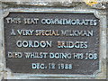
A plaque giving details of the Meer Stone seen at Image
Cricklade is the first town downstream on the River Thames. The town was founded by the Anglo-Saxons in the 9th century at the point where the Roman Ermin Way crosses the River Thames. It is one of the thirty burhs (fortified towns) recorded in the Burghal Hidage document, which describes a system of fortresses and fortified towns built around Wessex by King Alfred. The fortifications have been extensively excavated in several places on all four of its sides.
Image: © Michael Dibb
Taken: 25 Aug 2019
0.03 miles
4
![Cricklade houses [51]](https://s2.geograph.org.uk/geophotos/06/34/85/6348534_d2310b2b_120x120.jpg)
Cricklade houses [51]
Number 21 (nearest the camera) and number 22 Calcott Street, seen here, are, along with numbers 19A and 20, the remains of a row of seven houses built in the 1730s to create votes. They stand just outside the walls of the Saxon burgh and were much discussed in the disputed parliamentary election of 1774. There are brief details and links at: https://en.wikipedia.org/wiki/Cricklade_(UK_Parliament_constituency) Number 22 has had its door removed and has been merged with number 23. The row of four houses is listed for historical reasons with details at: https://historicengland.org.uk/listing/the-list/list-entry/1023091
Cricklade is the first town downstream on the River Thames. The town was founded by the Anglo-Saxons in the 9th century at the point where the Roman Ermin Way crosses the River Thames. It is one of the thirty burhs (fortified towns) recorded in the Burghal Hidage document, which describes a system of fortresses and fortified towns built around Wessex by King Alfred. The fortifications have been extensively excavated in several places on all four of its sides.
Image: © Michael Dibb
Taken: 25 Aug 2019
0.03 miles
5
![Cricklade houses [52]](https://s0.geograph.org.uk/geophotos/06/34/85/6348536_332481bf_120x120.jpg)
Cricklade houses [52]
Number 23 Calcutt Street is an early/mid 19th century rebuilding of a 1730s cottage. Listed for group value, grade II, with details at: https://historicengland.org.uk/listing/the-list/list-entry/1182905
Cricklade is the first town downstream on the River Thames. The town was founded by the Anglo-Saxons in the 9th century at the point where the Roman Ermin Way crosses the River Thames. It is one of the thirty burhs (fortified towns) recorded in the Burghal Hidage document, which describes a system of fortresses and fortified towns built around Wessex by King Alfred. The fortifications have been extensively excavated in several places on all four of its sides.
Image: © Michael Dibb
Taken: 25 Aug 2019
0.03 miles
6
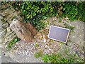
Meer stone, Cricklade
The meer stone is a boundary marker. It dates from at least ass early as the 18th century. It can be seen in context here Image
Image: © Brian Robert Marshall
Taken: 9 Jun 2024
0.03 miles
7
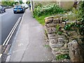
Calcutt Street, Cricklade
The stone in the lower left corner is a meer stone, a boundary marker. It can been seen in a little more detail here Image
Image: © Brian Robert Marshall
Taken: 9 Jun 2024
0.03 miles
8
![Cricklade houses [50]](https://s0.geograph.org.uk/geophotos/06/34/85/6348532_84dce108_120x120.jpg)
Cricklade houses [50]
Number 19A (nearest the camera) and number 20 Calcott Street, seen here, are, along with numbers 21 and 22, the remains of a row of seven houses built in the 1730s to create votes. They stand just outside the walls of the Saxon burgh and were much discussed in the disputed parliamentary election of 1774. There are brief details and links at: https://en.wikipedia.org/wiki/Cricklade_(UK_Parliament_constituency) The row of four houses is listed for historical reasons with details at: https://historicengland.org.uk/listing/the-list/list-entry/1023091
Cricklade is the first town downstream on the River Thames. The town was founded by the Anglo-Saxons in the 9th century at the point where the Roman Ermin Way crosses the River Thames. It is one of the thirty burhs (fortified towns) recorded in the Burghal Hidage document, which describes a system of fortresses and fortified towns built around Wessex by King Alfred. The fortifications have been extensively excavated in several places on all four of its sides.
Image: © Michael Dibb
Taken: 25 Aug 2019
0.04 miles
9
![Cricklade houses [49]](https://s0.geograph.org.uk/geophotos/06/34/85/6348528_960be8b5_120x120.jpg)
Cricklade houses [49]
Number 19 Calcutt Street is mid 19th century and is listed for group value, grade II, with details at: https://historicengland.org.uk/listing/the-list/list-entry/1023090
Cricklade is the first town downstream on the River Thames. The town was founded by the Anglo-Saxons in the 9th century at the point where the Roman Ermin Way crosses the River Thames. It is one of the thirty burhs (fortified towns) recorded in the Burghal Hidage document, which describes a system of fortresses and fortified towns built around Wessex by King Alfred. The fortifications have been extensively excavated in several places on all four of its sides.
Image: © Michael Dibb
Taken: 25 Aug 2019
0.05 miles