1
The Windmill pub, Swindon
The Windmill is a local pub for Freshbrook, west Swindon and is located beside the Freshbrook Centre shops.
Image: © Robert Ashby
Taken: 2 Jan 2013
0.05 miles
2
Entrance to Freshbrook Centre and a bus stop
Image: © Rob Purvis
Taken: 24 Jul 2020
0.06 miles
3
Footpath to Freshbrook Centre
Image: © Rob Purvis
Taken: 24 Jul 2020
0.07 miles
4
Freshbrook Village Centre, West Swindon
Row of shops with car park in front. The Post Office is inside Tesco Express.
Image: © Vieve Forward
Taken: 31 Dec 2012
0.07 miles
5
Whitehill Way, Swindon
The B4534 Whitehill Way heads north away from the A3102
Great Western Way at the western edge of Swindon.
Image: © Jaggery
Taken: 2 Feb 2013
0.11 miles
6
Whitehill Way, Freshbrook
Image: © David Howard
Taken: 26 Oct 2019
0.12 miles
7
Segregation on a path near Whitehill Way, Swindon
Cyclists are directed to use the left half of the path on the east side of the B4534 Whitehill Way.
Image: © Jaggery
Taken: 2 Feb 2013
0.16 miles
8
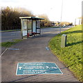
Directions on the pavement alongside Whitehill Way, Swindon
The directions for walkers and cyclists are at the southern end of the B4534 Whitehill Way,
near the Great Western Way junction.
Image: © Jaggery
Taken: 2 Feb 2013
0.17 miles
9
Johnsons of Swindon
Mazda and Volvo car dealership on the north side of Great Western Way at the western edge of Swindon.
Image: © Jaggery
Taken: 2 Feb 2013
0.19 miles
10
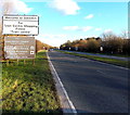
Western boundary of Swindon
The A3102 Great Western Way reaches the western edge of Swindon, Wiltshire, one of the largest towns in the UK. The population of the Borough of Swindon was 209,000 on the day of the 2011 census, an increase of 29,000 in ten years.
Image: © Jaggery
Taken: 2 Feb 2013
0.20 miles


