IMAGES TAKEN NEAR TO
High Street, SWINDON, SN5 4AD
Introduction
This page details the photographs taken nearby to High Street, SN5 4AD by members of the Geograph project.
The Geograph project started in 2005 with the aim of publishing, organising and preserving representative images for every square kilometre of Great Britain, Ireland and the Isle of Man.

There are currently over 7.5m images from over14,400 individuals and you can help contribute to the project by visiting https://www.geograph.org.uk
Image Map
Images are licensed for reuse under creativecommons.org/licenses/by-sa/2.0
Notes
- Clicking on the map will re-center to the selected point.
- The higher the marker number, the further away the image location is from the centre of the postcode.
Image Listing (47 Images Found)
Images are licensed for reuse under creativecommons.org/licenses/by-sa/2.0
Image
Details
Distance
1
![Purton features [4]](https://s0.geograph.org.uk/geophotos/06/35/68/6356820_69e4e2b9_120x120.jpg)
Purton features [4]
This fine 17th century doorway leads to College Farmhouse. Listed, grade II, with details at: https://historicengland.org.uk/listing/the-list/list-entry/1198379
Originally built round the parish church, manor and Tithe barn, the village moved and is now mostly spread out along the Bristol and Oxford coach road.
Image: © Michael Dibb
Taken: 28 Aug 2019
0.04 miles
2
![Purton buildings [9]](https://s3.geograph.org.uk/geophotos/06/35/68/6356819_aea7823c_120x120.jpg)
Purton buildings [9]
In a poor state of repair this former granary was originally part of College Farm. The granary is date 1754 and is listed, grade II, with details at: https://historicengland.org.uk/listing/the-list/list-entry/1356022
Originally built round the parish church, manor and Tithe barn, the village moved and is now mostly spread out along the Bristol and Oxford coach road.
Image: © Michael Dibb
Taken: 28 Aug 2019
0.04 miles
3
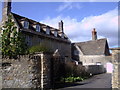
College Farm, High Street, Purton
Grade II* listed early 17th century farmhouse, once the home of Edward Hyde, Earl of Clarendon. Built of Cotswold limestone with a stone slate roof, it has a central gabled porch and five gabled dormer windows. The interior has a 17th century panelled parlour with a stone fireplace whose overmantel is carved with arms of Hyde family and the date 1626. http://www.britishlistedbuildings.co.uk/en-317962-college-farmhouse-purton http://history.wiltshire.gov.uk/community/getimage.php?id=2225
Image: © Vieve Forward
Taken: 3 Mar 2012
0.04 miles
4
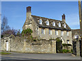
College Farm House, Purton
An early 17th century grade II*(star) listed building.
Image: © Robin Webster
Taken: 25 Mar 2017
0.05 miles
5
![Purton houses [8]](https://s2.geograph.org.uk/geophotos/06/35/68/6356818_07c1f56b_120x120.jpg)
Purton houses [8]
College Farmhouse is dated 1626. Now a private dwelling and not associated with a farm, the house contains a 17th century fully panelled parlour and several other original internal features. Listed, grade II*, with details at: https://historicengland.org.uk/listing/the-list/list-entry/1198361
Originally built round the parish church, manor and Tithe barn, the village moved and is now mostly spread out along the Bristol and Oxford coach road.
Image: © Michael Dibb
Taken: 28 Aug 2019
0.05 miles
7
![Purton features [5]](https://s1.geograph.org.uk/geophotos/06/35/68/6356821_eedf9a98_120x120.jpg)
Purton features [5]
Purton war memorial was dedicated in December, 1920 and has the names of 55 who died in WWI and 14 who died in WWII. Listed, grade II, with details at: https://historicengland.org.uk/listing/the-list/list-entry/1352664
Originally built round the parish church, manor and Tithe barn, the village moved and is now mostly spread out along the Bristol and Oxford coach road.
Image: © Michael Dibb
Taken: 28 Aug 2019
0.06 miles
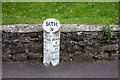
8
Purton Milestone
Old milestone by the Angel Inn, marking old coach route to Bath? Other side of stone notes distance to Wootton Bassett.
Image: © Jeremy Newcombe
Taken: 6 Nov 2016
0.06 miles
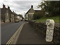
9
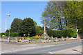
Purton War Memorial
High Street in Purton.
Image: © Wayland Smith
Taken: 25 Apr 2020
0.06 miles
10
![Purton buildings [11]](https://s3.geograph.org.uk/geophotos/06/35/68/6356827_155d2eea_120x120.jpg)
Purton buildings [11]
This barn, possibly once part of College Farm is in poor condition.
Originally built round the parish church, manor and Tithe barn, the village moved and is now mostly spread out along the Bristol and Oxford coach road.
Image: © Michael Dibb
Taken: 28 Aug 2019
0.06 miles