IMAGES TAKEN NEAR TO
Rope Yard, SWINDON, SN4 7BW
Introduction
This page details the photographs taken nearby to Rope Yard, SN4 7BW by members of the Geograph project.
The Geograph project started in 2005 with the aim of publishing, organising and preserving representative images for every square kilometre of Great Britain, Ireland and the Isle of Man.

There are currently over 7.5m images from over14,400 individuals and you can help contribute to the project by visiting https://www.geograph.org.uk
Image Map
Images are licensed for reuse under creativecommons.org/licenses/by-sa/2.0
Notes
- Clicking on the map will re-center to the selected point.
- The higher the marker number, the further away the image location is from the centre of the postcode.
Image Listing (193 Images Found)
Images are licensed for reuse under creativecommons.org/licenses/by-sa/2.0
Image
Details
Distance
1
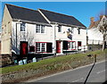
Telephone Exchange, Royal Wootton Bassett, Wilts
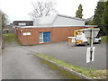
Situated in Rope Yard, this TE would appear to date from the early 1970s and has the code SSWOB. It provides telephone and broadband services to 5,133 residential and 406 non-residential premises in Royal Wootton Bassett plus Hook and Tockenham nearby. To the right of the photo can be seen the back of a Give Way road sign, whilst behind it is an Openreach vehicle. The numbering range of this TE is (01793) 84xxxx, 85xxxx, the (01793) referring to the Swindon group of fifteen TEs, and its postcode is SN4 7BW.
Image: © David Hillas
Taken: 13 Jan 2018
0.01 miles

3
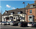
The Waggon & Horses viewed from the east, Royal Wootton Bassett
Viewed across High Street looking towards the corner of Rope Yard.
Image: © Jaggery
Taken: 2 Feb 2013
0.05 miles
4
The Waggon & Horses viewed from the south, Royal Wootton Bassett
Pub at 9 High Street. The large shadow on the left is being cast on a wall at the corner of Rope Yard.
Image: © Jaggery
Taken: 2 Feb 2013
0.06 miles
5
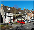
A late Victorian house, High Street, Royal Wootton Bassett
Below the black and white part of the house, the year 1887 is inscribed on the wall.
Image: © Jaggery
Taken: 2 Feb 2013
0.06 miles
6
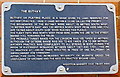
The Buthay plaque, Royal Wootton Bassett
The plaque is on the wall of The Croft. http://www.geograph.org.uk/photo/3378590
It records the former use of this area for archery practice.
Image: © Jaggery
Taken: 2 Feb 2013
0.06 miles
7

A3102 descends towards Brinkworth Brook
Image: © Stuart Logan
Taken: 16 May 2012
0.06 miles
8
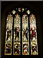
West Window, Wootton Bassett
Inside the medieval parish church of St Bartholomew and All Saints.
http://www.woottonbassett.gov.uk/
Image: © Colin Smith
Taken: 31 May 2010
0.06 miles
9
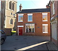
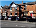
The Croft, Royal Wootton Bassett
Located on the corner of Church Street and Rope Yard, The Croft is the parish office
for St Bartholomew and All Saints church, http://www.geograph.org.uk/photo/3378506 a corner of which is on the left.
The Croft is also a coffee shop. Gifts, books and cards are on sale.
A plaque http://www.geograph.org.uk/photo/3378599 on the building records that this area was formerly reserved for archery practice.
Image: © Jaggery
Taken: 2 Feb 2013
0.06 miles
10
The Phoenix Bar, Royal Wootton Bassett
The bar is at 3-4 High Street.
Image: © Jaggery
Taken: 2 Feb 2013
0.06 miles