IMAGES TAKEN NEAR TO
Park Lane, SWINDON, SN4 0FY
Introduction
This page details the photographs taken nearby to Park Lane, SN4 0FY by members of the Geograph project.
The Geograph project started in 2005 with the aim of publishing, organising and preserving representative images for every square kilometre of Great Britain, Ireland and the Isle of Man.

There are currently over 7.5m images from over14,400 individuals and you can help contribute to the project by visiting https://www.geograph.org.uk
Image Map
Images are licensed for reuse under creativecommons.org/licenses/by-sa/2.0
Notes
- Clicking on the map will re-center to the selected point.
- The higher the marker number, the further away the image location is from the centre of the postcode.
Image Listing (16 Images Found)
Images are licensed for reuse under creativecommons.org/licenses/by-sa/2.0
Image
Details
Distance
1
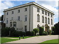
Burderop House
Burderop house was the subject of Richard Jefferies book 'Round About a Great Estate' and the home of the Calley family. Today it is the headquarters of the Halcrow organisation.
Image: © Dr Duncan Pepper
Taken: 18 May 2008
0.08 miles
2
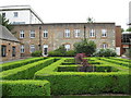
Parterre, Burderop House
A good example of a box hedge parterre, situated behind Burderop house.
Image: © Dr Duncan Pepper
Taken: 18 May 2008
0.10 miles
3
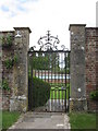
Walled garden, Burderop House
A fine wrought iron gate leads the view into this old walled garden at Burderop House.
Image: © Dr Duncan Pepper
Taken: 18 May 2008
0.11 miles
4
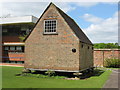
Grain Store, Burderop House
A typical south of England grain store, standing on staddle stones to keep the rats out. This one has been beautifully restored by the Halcrow organisation who currently occupy Burderop house.
Image: © Dr Duncan Pepper
Taken: 18 May 2008
0.12 miles
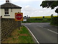
6
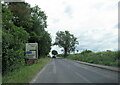
Old Toll House by the B4005, Marlborough Road, Burderop
Toll House by the B4005, in parish of Chiseldon (Swindon District), Toll House, West of Burderop Farm, Marlborough Road, SN4 7SA.
Grade II listed.
List Entry Number: 1023325 https://historicengland.org.uk/listing/the-list/list-entry/1023325
Surveyed
Milestone Society National ID: WI.CHS01
Image: © Alan Rosevear
Taken: 7 Mar 2005
0.13 miles
7
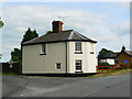
6 Burderop, Swindon (1)
The former toll house is situated on the corner of the B4005 road between Wroughton, behind the viewpoint, and Chiseldon to the east past the left of the house. The road to the right leads to Barbury Castle. It is marked as a 'no through road' now but between 1761 and 1875 it was a turnpike road to Marlborough and Everleigh and the tolls were taken at the house then named Burderop Gate. Thanks to a fellow contributor for the additional information. Listed Grade II.
Image: © Brian Robert Marshall
Taken: 30 Jun 2010
0.13 miles
8
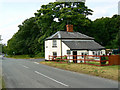
6 Burderop, Swindon (2)
This is another view of the former toll house seen here http://www.geograph.org.uk/photo/1945986
Image: © Brian Robert Marshall
Taken: 30 Jun 2010
0.13 miles
10
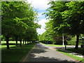
Avenue of Trees
The magnificent avenue of lime trees leading into Burderop Park.
Image: © Dr Duncan Pepper
Taken: 18 May 2008
0.14 miles