IMAGES TAKEN NEAR TO
Morris Street, SWINDON, SN2 2HS
Introduction
This page details the photographs taken nearby to Morris Street, SN2 2HS by members of the Geograph project.
The Geograph project started in 2005 with the aim of publishing, organising and preserving representative images for every square kilometre of Great Britain, Ireland and the Isle of Man.

There are currently over 7.5m images from over14,400 individuals and you can help contribute to the project by visiting https://www.geograph.org.uk
Image Map
Images are licensed for reuse under creativecommons.org/licenses/by-sa/2.0
Notes
- Clicking on the map will re-center to the selected point.
- The higher the marker number, the further away the image location is from the centre of the postcode.
Image Listing (42 Images Found)
Images are licensed for reuse under creativecommons.org/licenses/by-sa/2.0
Image
Details
Distance
1
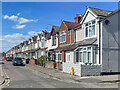
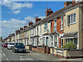
Drew Street
Early 20th Century housing in Drew Street, seen from where it crosses Morris Street. The street was first shown on the 1923 25 inch map.
Image: © Ian Capper
Taken: 14 Jul 2022
0.04 miles
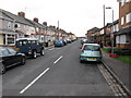
2
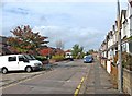
Drew Street
This street is typical of many in the Rodbourne area, with a combination of both modern housing, and much older residential properties. The latter date from 1907, and were designed by William Drew, a local architect. The street was named after him. The modern properties in this street are mainly flats, known as Mannington Court, built since the turn of the present century.
Image: © P L Chadwick
Taken: 5 Oct 2010
0.05 miles
3
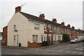
Houses at Morris Street / Montagu Street junction
There is an OS benchmark Image on the corner, left hand face, of the nearest house
Image: © Roger Templeman
Taken: 15 Mar 2016
0.06 miles
4
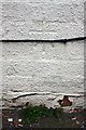
Benchmark on #67 Montagu Street
Ordnance Survey cut mark benchmark described on the Bench Mark Database at http://www.bench-marks.org.uk/bm74261
Image: © Roger Templeman
Taken: 15 Mar 2016
0.06 miles
5
Montagu Street
Early 20th Century terraced housing in Montagu Street, seen from where it crosses Morris Street. The street was first shown on the 1923 25 inch map.
Image: © Ian Capper
Taken: 14 Jul 2022
0.08 miles
7
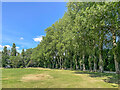
Mannington Recreation Ground
Tree lined path on the edge of Mannington Recreation Ground, a large open space between Even Swindon and the B4006.
Image: © Ian Capper
Taken: 14 Jul 2022
0.12 miles
8
Rose Street
The older parts of Rodbourne were laid out on a grid pattern, with mainly terraced housing. In recent years there has been much infilling and extension, with modern housing, some of which has been built on the sites of demolished buildings, or on former allotment land. Rose Street is typical in containing both old and new housing stock.
Image: © P L Chadwick
Taken: 5 Oct 2010
0.12 miles
9
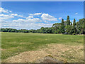
Mannington Recreation Ground
Large open space between Even Swindon and the B4006.
Image: © Ian Capper
Taken: 14 Jul 2022
0.13 miles
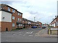
10
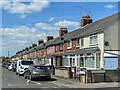
Rose Street
Early 20th Century terraced housing in Rose Street, seen from where it crosses Morris Street. The street was shown as laid out on the 1923 25 inch map, but with no development on this section.
Image: © Ian Capper
Taken: 14 Jul 2022
0.13 miles