IMAGES TAKEN NEAR TO
Station Approach, MALMESBURY, SN16 9RG
Introduction
This page details the photographs taken nearby to Station Approach, SN16 9RG by members of the Geograph project.
The Geograph project started in 2005 with the aim of publishing, organising and preserving representative images for every square kilometre of Great Britain, Ireland and the Isle of Man.

There are currently over 7.5m images from over14,400 individuals and you can help contribute to the project by visiting https://www.geograph.org.uk
Image Map
Images are licensed for reuse under creativecommons.org/licenses/by-sa/2.0
Notes
- Clicking on the map will re-center to the selected point.
- The higher the marker number, the further away the image location is from the centre of the postcode.
Image Listing (23 Images Found)
Images are licensed for reuse under creativecommons.org/licenses/by-sa/2.0
Image
Details
Distance
1
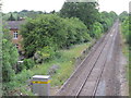
Minety & Ashton Keynes railway station (site), Wiltshire, 2010
Opened in 1841 on the Great Western Railway's line from Swindon to Stroud, this station closed in 1964. Four years later, the line was singled.
View north west towards Oaksey and Stroud, three years before the line was redoubled - see Image for a 2018 view.
Image: © Nigel Thompson
Taken: 2 Jul 2010
0.02 miles
2
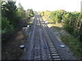
Minety & Ashton Keynes railway station (site), Wiltshire
Opened in 1841 on the Great Western Railway's line from Swindon to Stroud, this station closed in 1964. Four years later, the line was singled.
View north west towards Oaksey and Stroud, four years after the line had been redoubled - see Image for a 2010 view. The iron railings on the left that would have been at the rear of the platforms appear to be the only clue there was ever a station here.
Image: © Nigel Thompson
Taken: 10 Oct 2018
0.03 miles

4
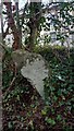
Old Milestone, Minety
Opposite the White Inn pub, falling down the bank. Originally erected by the Faringdon to Acton Turville Turnpike Trust, but undoubtedly moved with the road when the railway was built and the road kinked to go over the tracks.
Inscription: To / Malmesbury / 7 / Miles // To / Cricklade / 5 / Miles
Milestone Society ID: WI_MYCK07
Image: © Tom Blanden
Taken: 23 Nov 2022
0.04 miles
5
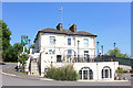
Vale of the White Horse Inn
Public House in Minety.
Image: © Wayland Smith
Taken: 30 May 2020
0.04 miles
6
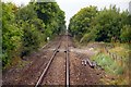
Crossing at the end of the former Minety Station
Image: © Steve Daniels
Taken: 2 Sep 2009
0.05 miles
7
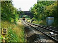
13.46 from Swindon to Gloucester, Minety
The local stopping train seen closer up here Image is seen a few seconds earlier as it is about to pass under the Station Road bridge on the eastern edge of Minety. The marker at the left indicates the distance from here to London Paddington, i.e. 85.75 miles (138 kms). The mechanism in the centre of the track is part of the Automatic Warning system (AWS), a means by which an alarm sounds in the driver's cab whenever a train approaches a caution or stop signal. If the driver fails to acknowledge the alarm, the train brakes are applied. More on train protection here http://www.railway-technical.com/sigtxt7.shtml (Thanks to Dave Hitchborne for the information on AWS).
NOTE. This image has a detailed ‘shared description’ which you won’t see by viewing this image on a slideshow. To read it click on the image.
Image: © Brian Robert Marshall
Taken: 22 Aug 2011
0.06 miles
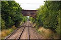
9
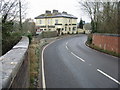
Vale of the White Horse Inn on Station Road
Image: © Nick Smith
Taken: 4 Jan 2009
0.08 miles