13.46 from Swindon to Gloucester, Minety
Introduction
The photograph on this page of 13.46 from Swindon to Gloucester, Minety by Brian Robert Marshall as part of the Geograph project.
The Geograph project started in 2005 with the aim of publishing, organising and preserving representative images for every square kilometre of Great Britain, Ireland and the Isle of Man.

There are currently over 7.5m images from over 14,400 individuals and you can help contribute to the project by visiting https://www.geograph.org.uk
13.46 from Swindon to Gloucester, Minety
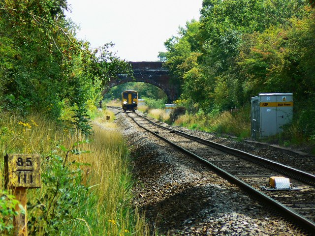
Image: © Brian Robert Marshall Taken: 22 Aug 2011
The local stopping train seen closer up here Image is seen a few seconds earlier as it is about to pass under the Station Road bridge on the eastern edge of Minety. The marker at the left indicates the distance from here to London Paddington, i.e. 85.75 miles (138 kms). The mechanism in the centre of the track is part of the Automatic Warning system (AWS), a means by which an alarm sounds in the driver's cab whenever a train approaches a caution or stop signal. If the driver fails to acknowledge the alarm, the train brakes are applied. More on train protection here http://www.railway-technical.com/sigtxt7.shtml (Thanks to Dave Hitchborne for the information on AWS). NOTE. This image has a detailed ‘shared description’ which you won’t see by viewing this image on a slideshow. To read it click on the image.
Images are licensed for reuse under creativecommons.org/licenses/by-sa/2.0
Image Location
Latitude
51.614218
Longitude
-1.950993