IMAGES TAKEN NEAR TO
Joseph Street, SWINDON, SN1 5LW
Introduction
This page details the photographs taken nearby to Joseph Street, SN1 5LW by members of the Geograph project.
The Geograph project started in 2005 with the aim of publishing, organising and preserving representative images for every square kilometre of Great Britain, Ireland and the Isle of Man.

There are currently over 7.5m images from over14,400 individuals and you can help contribute to the project by visiting https://www.geograph.org.uk
Image Map
Images are licensed for reuse under creativecommons.org/licenses/by-sa/2.0
Notes
- Clicking on the map will re-center to the selected point.
- The higher the marker number, the further away the image location is from the centre of the postcode.
Image Listing (131 Images Found)
Images are licensed for reuse under creativecommons.org/licenses/by-sa/2.0
Image
Details
Distance
1
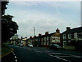
Marlborough Street, Swindon
On the north bank of the former Wilts & Berks canal. Built between 1885 and 1899. The canal closed in 1914.
Image: © Christine Johnstone
Taken: 14 Jul 2022
0.03 miles
2
Read Street, Swindon
On the north bank of the former Wilts & Berks canal. Built between 1885 and 1899. The canal closed in 1914.
Image: © Christine Johnstone
Taken: 14 Jul 2022
0.04 miles
3
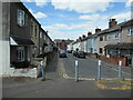
Traffic management on the former Wilts & Berks canal
Double yellow lines and bollards, because this is road access to the back of houses, as well as a public footpath. The Wilts & Berks canal opened in 1810, linking the Kennet & Avon canal with the River Thames and running right through Swindon. It closed in 1914, but is now partly restored.
Image: © Christine Johnstone
Taken: 14 Jul 2022
0.05 miles
4
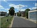
Cambria Place, Swindon
This terrace of houses is at the southern edge of the small but distinctive area of Victorian houses built by the Great Western Railway specifically for Welsh workers and their families. This is a view to the west. Car parking in the central area of Swindon is at a premium.
Image: © Brian Robert Marshall
Taken: 16 Sep 2008
0.06 miles
6
The former Wilts & Berks canal, heading south-west
Between Westcott Place and Albion Street, Swindon. The Wilts & Berks canal opened in 1810, linking the Kennet & Avon canal with the River Thames and running right through Swindon. It closed in 1914, but is now partly restored.
Image: © Christine Johnstone
Taken: 14 Jul 2022
0.07 miles
7
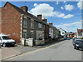
Cambria Baptist Chapel, Cambria Place, Swindon
This small area of housing, contained in an area of about 150 metres by 120 metres, was developed in the 1800s by the Great Western Railway to house workers from Wales and their families. The chapel is now used for other purposes, probably storage. A plaque on the front is dated 1866. Unlike the larger Railway Village http://www.geograph.org.uk/photo/511606 Cambria Place never passed into Council ownership and isn't listed so it has become an area of private sector houses. This has meant that it has, to some extent, lost its integrity but I don't think that matters a great deal. Residents here take a pride in their properties.
Image: © Brian Robert Marshall
Taken: 16 Sep 2008
0.09 miles
8
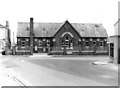
Clifton Street Schools, Radnor Street
Facing the end of Clifton Street, with access from both Radnor Street and William Street, Clifton Street Schools comprised both infant and junior schools. They were opened on this site in stages, over a short period of years commencing in 1884. In 1950 there was considerable enlargement and alterations. Over the central windows is engraved "Clifton Street Schools". On the front boundary wall is a street name sign for Radnor Street. When photographed the schools were still in use. Some years ago they closed and pupils went to the newly built Robert Le Kyng Primary School in nearby Westcott Street.
Today the buildings have another use, as can be seen in the recent photograph of Brian Robert Marshall:- Image The building externally has not changed much, except that the brick built boundary wall with metal railings, that used to front Radnor Street, has been demolished so as to provide car parking.
Image: © P L Chadwick
Taken: Unknown
0.09 miles
9
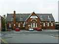
Former Clifton Street Schools, Radnor Street, Swindon
This fine Victorian redbrick school building has another life now as the offices of SSSL Ltd (Swindon Silicon Systems Limited) a hi-tech company. To quote from their website:
"Swindon Silicon Systems Limited is an innovative fabless semiconductor company that designs, develops and supplies highly integrated, performance driven, affordable, Custom Mixed Signal ASIC's and specialises in sensor interfaces for the Automotive and Industrial sectors."
Image: © Brian Robert Marshall
Taken: 19 Sep 2009
0.09 miles