IMAGES TAKEN NEAR TO
Highfield, CHIPPENHAM, SN15 2HP
Introduction
This page details the photographs taken nearby to Highfield, SN15 2HP by members of the Geograph project.
The Geograph project started in 2005 with the aim of publishing, organising and preserving representative images for every square kilometre of Great Britain, Ireland and the Isle of Man.

There are currently over 7.5m images from over14,400 individuals and you can help contribute to the project by visiting https://www.geograph.org.uk
Image Map
Images are licensed for reuse under creativecommons.org/licenses/by-sa/2.0
Notes
- Clicking on the map will re-center to the selected point.
- The higher the marker number, the further away the image location is from the centre of the postcode.
Image Listing (15 Images Found)
Images are licensed for reuse under creativecommons.org/licenses/by-sa/2.0
Image
Details
Distance
2
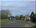
2010 : Highfield, Bromham
A modern development east of Bromham in a triangle formed by Highfield, The Pound and the A342.
Image: © Maurice Pullin
Taken: 21 Mar 2010
0.08 miles
3
![A walk around Bromham [10]](https://s1.geograph.org.uk/geophotos/07/44/06/7440689_a0a0ea62_120x120.jpg)
A walk around Bromham [10]
A tennis court alongside Highfield.
From the car park in front of the Greyhound public house, the route leads through fields and along Highfield to cross the A342 road. The next path leads past Bromham House Farm to Turnpike Farm and on to Wick Farm. Then paths through fields to Chittoe Heath and along minor roads to Nonsuch Nurseries. Another path through fields leads to a surfaced path at the edge of Wyatt’s Wood, this leads to the High Street and back to the starting point. Almost exactly 4 miles.
Image: © Michael Dibb
Taken: 26 Feb 2023
0.10 miles
4
![A walk around Bromham [9]](https://s0.geograph.org.uk/geophotos/07/44/06/7440688_6085671c_120x120.jpg)
A walk around Bromham [9]
A play area alongside Highfield.
From the car park in front of the Greyhound public house, the route leads through fields and along Highfield to cross the A342 road. The next path leads past Bromham House Farm to Turnpike Farm and on to Wick Farm. Then paths through fields to Chittoe Heath and along minor roads to Nonsuch Nurseries. Another path through fields leads to a surfaced path at the edge of Wyatt’s Wood, this leads to the High Street and back to the starting point. Almost exactly 4 miles.
Image: © Michael Dibb
Taken: 26 Feb 2023
0.12 miles
5
![A walk around Bromham [8]](https://s2.geograph.org.uk/geophotos/07/44/06/7440686_da583969_120x120.jpg)
A walk around Bromham [8]
The house to the left is Pound House. Built in the early 19th century of red brick with ashlar dressings under a slate roof. The parallel rear range has an ironstone rubble rear wall. Listed, grade II, with details at: https://historicengland.org.uk/listing/the-list/list-entry/1033896
To the right is the former school. Established in 1843, it became a British School in 1862 and moved to this building in 1878. The building was enlarged in 1901 and the school became a County School in 1907. The school closed in 1984.
From the car park in front of the Greyhound public house, the route leads through fields and along Highfield to cross the A342 road. The next path leads past Bromham House Farm to Turnpike Farm and on to Wick Farm. Then paths through fields to Chittoe Heath and along minor roads to Nonsuch Nurseries. Another path through fields leads to a surfaced path at the edge of Wyatt’s Wood, this leads to the High Street and back to the starting point. Almost exactly 4 miles.
Image: © Michael Dibb
Taken: 26 Feb 2023
0.13 miles
6
![A walk around Bromham [7]](https://s3.geograph.org.uk/geophotos/07/44/06/7440679_4bcd06a1_120x120.jpg)
A walk around Bromham [7]
The Pound continues to the right, Highfield is the road to the left.
From the car park in front of the Greyhound public house, the route leads through fields and along Highfield to cross the A342 road. The next path leads past Bromham House Farm to Turnpike Farm and on to Wick Farm. Then paths through fields to Chittoe Heath and along minor roads to Nonsuch Nurseries. Another path through fields leads to a surfaced path at the edge of Wyatt’s Wood, this leads to the High Street and back to the starting point. Almost exactly 4 miles.
Image: © Michael Dibb
Taken: 26 Feb 2023
0.15 miles
7
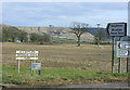
2010 : Signs at the entrance to Bromham House Farm
Seen from the A342.
A.J.Butler makes certain few will miss his enterprise.
Image: © Maurice Pullin
Taken: 21 Mar 2010
0.16 miles
8
![A walk around Bromham [11]](https://s2.geograph.org.uk/geophotos/07/44/06/7440690_59cc6814_120x120.jpg)
A walk around Bromham [11]
The route crosses the busy A342 road. Roughmoor Cottages are seen in the distance.
From the car park in front of the Greyhound public house, the route leads through fields and along Highfield to cross the A342 road. The next path leads past Bromham House Farm to Turnpike Farm and on to Wick Farm. Then paths through fields to Chittoe Heath and along minor roads to Nonsuch Nurseries. Another path through fields leads to a surfaced path at the edge of Wyatt’s Wood, this leads to the High Street and back to the starting point. Almost exactly 4 miles.
Image: © Michael Dibb
Taken: 26 Feb 2023
0.17 miles
9
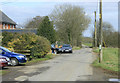
2010 : Lane to Bromham House Farm
Seen from the A342.
The farm is about 400 yards along followed by a footpath to Heddington Wick.
Image: © Maurice Pullin
Taken: 21 Mar 2010
0.20 miles
10
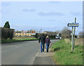
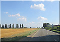
2010 : A342 Walkers passing Hawkstreet
Heading north toward Derry Hill and Chippenham, though I doubt they will get that far.
Image: © Maurice Pullin
Taken: 21 Mar 2010
0.21 miles