IMAGES TAKEN NEAR TO
Rookery Lane, CHIPPENHAM, SN14 8HL
Introduction
This page details the photographs taken nearby to Rookery Lane, SN14 8HL by members of the Geograph project.
The Geograph project started in 2005 with the aim of publishing, organising and preserving representative images for every square kilometre of Great Britain, Ireland and the Isle of Man.

There are currently over 7.5m images from over14,400 individuals and you can help contribute to the project by visiting https://www.geograph.org.uk
Image Map
Images are licensed for reuse under creativecommons.org/licenses/by-sa/2.0
Notes
- Clicking on the map will re-center to the selected point.
- The higher the marker number, the further away the image location is from the centre of the postcode.
Image Listing (8 Images Found)
Images are licensed for reuse under creativecommons.org/licenses/by-sa/2.0
Image
Details
Distance
1
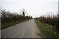
Rookery Lane
Looking south along Rookery Lane.
Image: © Derek Hawkins
Taken: 18 Feb 2007
0.02 miles
2
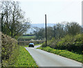
2010 : Rookery Lane again
This time looking south with the row of trees marking Freezing Hill on the skyline. Image
Image: © Maurice Pullin
Taken: 23 Apr 2010
0.11 miles
3
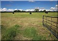
Bales near Home Farm
A view from Rookery Lane.
Image: © Derek Harper
Taken: 29 May 2015
0.18 miles
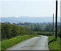
4
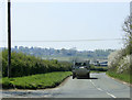
2010 : Minor road between Pucklechurch and Hinton
At the end of Rookery Lane outside Lower Fields Farm.
Looking east, the Cotswolds escarpment can be seen in the distance.
Image: © Maurice Pullin
Taken: 23 Apr 2010
0.20 miles
5
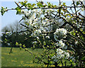
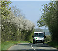
2010 : Blackthorn in flower
Prunus Spinosa or sloe has also been known as "Mother of the Woods" or "Dark Crone of the Woods."
Avoid picking in August when the fruit is very bitter, better to leave them to the end of October at the earliest.
Many people find sloes unpleasant even then due to their bitterness, but sloe gin - ah! now that is a different matter. A recipe can be found at http://www.sloe.biz/ and there are others. The spent sloes can be covered with melted plain chocolate with sugar to taste for an extra treat.
Image: © Maurice Pullin
Taken: 23 Apr 2010
0.21 miles
6
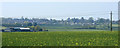
2010 : West from Rookery Lane
A pasture with dandelions then Churchmead Farm to the left. Then a view of Pucklechurch with its parish church to the right.
The valley between is occupied by the Feltham Brook.
Image: © Maurice Pullin
Taken: 23 Apr 2010
0.23 miles
7
2010 : Minor road between Hinton and Pucklechurch
Outside Lower Fields Farm. Heading west to Pucklechurch.
Image: © Maurice Pullin
Taken: 23 Apr 2010
0.23 miles
8
2010 : Rookery Lane looking south
Toward Doynton.
Freezing Hill and Lansdown are in the background.
Image: © Maurice Pullin
Taken: 23 Apr 2010
0.25 miles