IMAGES TAKEN NEAR TO
George Lane, SN14 8FJ
Introduction
This page details the photographs taken nearby to George Lane, SN14 8FJ by members of the Geograph project.
The Geograph project started in 2005 with the aim of publishing, organising and preserving representative images for every square kilometre of Great Britain, Ireland and the Isle of Man.

There are currently over 7.5m images from over14,400 individuals and you can help contribute to the project by visiting https://www.geograph.org.uk
Image Map
Images are licensed for reuse under creativecommons.org/licenses/by-sa/2.0
Notes
- Clicking on the map will re-center to the selected point.
- The higher the marker number, the further away the image location is from the centre of the postcode.
Image Listing (31 Images Found)
Images are licensed for reuse under creativecommons.org/licenses/by-sa/2.0
Image
Details
Distance
1
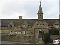
Alms Houses
At the Western end of Marshfield High Street.
Image: © Dr Duncan Pepper
Taken: 9 Mar 2009
0.11 miles
2
Crispe Almshouses, Marshfield
A row of 8 almshouses and central chapel, dated "1612" - "1619", for the Crispe family at the entry into Marshfield from the west. Each of the houses originally consisted of one room with a stone spiral staircase in one corner leading to a bedroom above. Earth closets at the top of the back gardens and a well in front of No 5 served the residents until 1939, when water and sewage services were connected. An extension at the rear of the houses in 1977 provided a kitchen and bathroom/toilet downstairs and a modern staircase for each house, plus central heating.
Image: © Eirian Evans
Taken: 1 Feb 2016
0.12 miles
3
Crispe Almshouses, Marshfield
A row of 8 almshouses and central chapel, dated "1612" - "1619", for the Crispe family at the entry into Marshfield from the west. Each of the houses originally consisted of one room with a stone spiral staircase in one corner leading to a bedroom above. Earth closets at the top of the back gardens and a well in front of No 5 served the residents until 1939, when water and sewage services were connected. An extension at the rear of the houses in 1977 provided a kitchen and bathroom/toilet downstairs and a modern staircase for each house, plus central heating.
Image: © Eirian Evans
Taken: 16 Feb 2011
0.12 miles
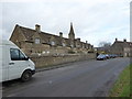
4
2010 : High Street, Marshfield looking west
Seen from the junction with St.Martin's Lane.
Formerly the A420 until Marshfield was relieved by its bypass.
Image: © Maurice Pullin
Taken: 10 Apr 2010
0.12 miles
5
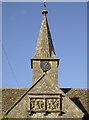
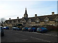
Almshouses spire
The old houses also boast a private chapel, of which the spire rises above the roofline. The Crispe brothers, Nicholas and Ellis, were local men who made their fortunes as merchants in London; they provided these almshouses for the benefit of their fellow villagers. Nicholas was a member of the Skinners' Company and Ellis the Salters' Company - hence the two coats of arms.
Image: © Neil Owen
Taken: 18 Oct 2016
0.12 miles
6
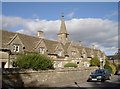
Crispe Almshouses
Built in the early 1600s and, as often the case, at the end of the village.
Image: © Neil Owen
Taken: 18 Oct 2016
0.12 miles
7
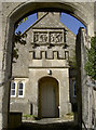
Almshouses gate
The Crispe Almshouses, crests and entrance.
Image: © Neil Owen
Taken: 18 Oct 2016
0.12 miles
8
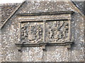
Crispe coat of arms, Marshfield
These 2 sets of Crispe armorial bearings are set above the porch on a central wide gable of the Marshfield almshouses. The Crispes were Marshfield men who had become wealthy London merchants. Nicholas was a member of the Skinners' Company and Ellis of the Salters' Company. The coats-of-arms are of these companies.
Image: © Eirian Evans
Taken: 16 Feb 2011
0.12 miles
9
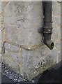
Two benchmarks on the corner
This corner of a house in Marshfield's High Street has two cutmarks, and at different heights at that! See http://www.bench-marks.org.uk/bm79800 for the entry in the Benchmark Database and Image] for a wider view.
Image: © Neil Owen
Taken: 18 Oct 2016
0.13 miles
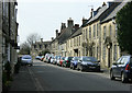
10
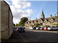
View to the almshouses
Looking west along the High Street, with the old almshouses in the background. Interestingly, the corner of the house at left of shot has not one but two benchmarks! See Image] for a closer look.
Image: © Neil Owen
Taken: 18 Oct 2016
0.13 miles