IMAGES TAKEN NEAR TO
Burton Farm Close, CHIPPENHAM, SN14 7PG
Introduction
This page details the photographs taken nearby to Burton Farm Close, SN14 7PG by members of the Geograph project.
The Geograph project started in 2005 with the aim of publishing, organising and preserving representative images for every square kilometre of Great Britain, Ireland and the Isle of Man.

There are currently over 7.5m images from over14,400 individuals and you can help contribute to the project by visiting https://www.geograph.org.uk
Image Map
Images are licensed for reuse under creativecommons.org/licenses/by-sa/2.0
Notes
- Clicking on the map will re-center to the selected point.
- The higher the marker number, the further away the image location is from the centre of the postcode.
Image Listing (74 Images Found)
Images are licensed for reuse under creativecommons.org/licenses/by-sa/2.0
Image
Details
Distance
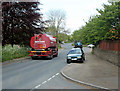
1
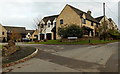
Burton Farm Close, Burton
Viewed across Nettleton Road.
Image: © Jaggery
Taken: 24 Nov 2013
0.03 miles
2
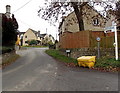
Nettleton Road, Burton
Sign arms point the way to the village post office & store, and to Nettleton and West Kington.
Image: © Jaggery
Taken: 24 Nov 2013
0.03 miles
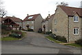
3
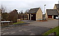
Matching electricity substation and houses in Burton
On the left, the substation in Burton Farm Close is made from the same materials as, and is in a similar style to, adjacent houses.
Image: © Jaggery
Taken: 24 Nov 2013
0.03 miles
4
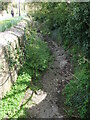
The By Brook is barely a trickle
The waters normally rise near Junction 18 of the M5, flow through Burton and on towards Castle Combe. This April has been a rather dry one.
Image: © Neil Owen
Taken: 8 Apr 2021
0.03 miles
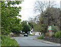
5
2010 : B4039 The Street, Burton
Seen from the Nettleton Road junction heading east toward Castle Combe.
The Watson fuel tanker has just made a delivery and is off to his next call.
Note the tractor in the background equipped for trimming hedgerows.
Image: © Maurice Pullin
Taken: 17 May 2010
0.04 miles
6

2010 : Nettleton Road, Burton
Minor road heading south from Burton to Nettleton.
Image: © Maurice Pullin
Taken: 17 May 2010
0.04 miles
7
Church Rise, Burton
Houses built in the 21st century.
Image: © Jaggery
Taken: 24 Nov 2013
0.05 miles
8
2010 : B4039 passing through Burton, Wiltshire
Heading west toward Acton Turville. The next turning left is Nettleton Road.
A sample of what is available at:http://www.burtonwilts.org.uk/Home.html
"Burton is a small village in the Cotswolds Area of Outstanding Natural Beauty. It is about 8 miles west of Chippenham and lies in the Electoral Parish of Nettleton. There is a record of Burton dating back to AD 1204, and more recently, Book 44 Wiltshire of the topographical collections of John Aubrey 1659-70."
Image: © Maurice Pullin
Taken: 17 May 2010
0.05 miles
9

A seat on the green
A small triangle of grass is surroundded by tarmac. That has not stopped it being a place for rest and reflection.
Image: © Neil Owen
Taken: 8 Apr 2021
0.06 miles
10
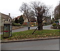
Grass triangle in Burton
Viewed across the B4039. The left fork ahead is Nettleton Road. The right fork is Church Hill.
Image: © Jaggery
Taken: 24 Nov 2013
0.06 miles