IMAGES TAKEN NEAR TO
Nettleton, CHIPPENHAM, SN14 7NH
Introduction
This page details the photographs taken nearby to SN14 7NH by members of the Geograph project.
The Geograph project started in 2005 with the aim of publishing, organising and preserving representative images for every square kilometre of Great Britain, Ireland and the Isle of Man.

There are currently over 7.5m images from over14,400 individuals and you can help contribute to the project by visiting https://www.geograph.org.uk
Image Map
Images are licensed for reuse under creativecommons.org/licenses/by-sa/2.0
Notes
- Clicking on the map will re-center to the selected point.
- The higher the marker number, the further away the image location is from the centre of the postcode.
Image Listing (8 Images Found)
Images are licensed for reuse under creativecommons.org/licenses/by-sa/2.0
Image
Details
Distance
1
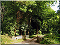
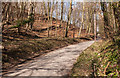
Entrance to Gatcombe Mill
The mill is in more or less in the centre of the square but this entrance is in the northern half of the square.
Image: © Pam Brophy
Taken: 23 Aug 2005
0.09 miles
2
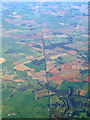
The Fosse Way from the air
Crossed by the M4 Motorway near Littleton Drew. Manor House Golf Club is in the lower right of the photo which was taken from a Prague bound flight from Bristol.
This http://en.wikipedia.org/wiki/Fosse_Way provides information about The Fosse Way.
Image: © Thomas Nugent
Taken: 11 Oct 2010
0.09 miles
3
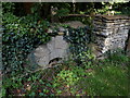
Mill Stone at Gatcombe Mill
This stone at the entrance to the drive of Gatcombe Mill is a French burr stone made from stone from France. There are two stones , one at either side of the drive gateway.
Image: © Nigel Mykura
Taken: 20 Aug 2012
0.17 miles
4
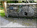
Mill Stone
This mill stone is one of two at the entrance to Gatcombe Mill. This one is made from Millstone grit and the other from French Burr stone. The burr stone is made from a number of small pieces but this one is a single block of stone.
Image: © Nigel Mykura
Taken: 20 Aug 2012
0.17 miles
5
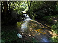
Pollution at Fosse Bridge
This stream flows under the Fosse Way where the Roman road crosses a deep valley. There is a small weir which was originally the off-take for Gatcombe Mill further down the stream. Rubbish has been thrown into the stream from the bridge from which this photo was taken.
Image: © Nigel Mykura
Taken: 20 Aug 2012
0.17 miles
6
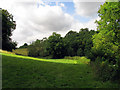
Pasture near Nettleton
This field is opposite the entrance to Gatcombe Mill. The square is mostly farmland with some woodland and a long barrow.
Image: © Pam Brophy
Taken: 23 Aug 2005
0.19 miles
8
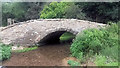
Bridge over Bybrook
Carefully restored by the Cotswold Voluntary Wardens in 2015/6. Interesting family crest can just be seen.
Image: © Rick Crowley
Taken: 21 Aug 2016
0.23 miles