IMAGES TAKEN NEAR TO
Kington St. Michael, CHIPPENHAM, SN14 6JR
Introduction
This page details the photographs taken nearby to SN14 6JR by members of the Geograph project.
The Geograph project started in 2005 with the aim of publishing, organising and preserving representative images for every square kilometre of Great Britain, Ireland and the Isle of Man.

There are currently over 7.5m images from over14,400 individuals and you can help contribute to the project by visiting https://www.geograph.org.uk
Image Map
Images are licensed for reuse under creativecommons.org/licenses/by-sa/2.0
Notes
- Clicking on the map will re-center to the selected point.
- The higher the marker number, the further away the image location is from the centre of the postcode.
Image Listing (11 Images Found)
Images are licensed for reuse under creativecommons.org/licenses/by-sa/2.0
Image
Details
Distance
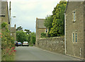
1
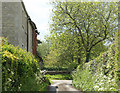
2010 : Byroad and cottages, Kington St. Michael
To the north of the village.
Image: © Maurice Pullin
Taken: 17 May 2010
0.01 miles
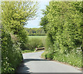
2
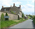
2010 : Minor road entering Kington St. Michael
From the north.
New Priory Stud is to the left behind the village sign.
Image: © Maurice Pullin
Taken: 17 May 2010
0.06 miles
3
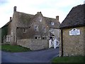
New Priory Equestrian Centre
Addiction therapy for horses?
Image: © Roger Cornfoot
Taken: 22 Jan 2007
0.08 miles
4
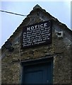
Take notice
Those pesky magistrates!
Image: © Roger Cornfoot
Taken: 23 Jan 2007
0.08 miles
5
2010 : North from Kington St. Michael
At the bottom of Honey Knob Hill.
Image: © Maurice Pullin
Taken: 17 May 2010
0.11 miles
6
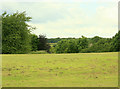
2009 : Pasture north west of Grove Lane
Near Kington St. Michael.
The land drops into a valley on the other side of this field, which appears to have been recently mowed. A stream at the bottom runs east and joins the Bristol Avon near Christian Malford.
Image: © Maurice Pullin
Taken: 20 Jun 2009
0.14 miles
7
2009 : Minor road leaving Kington St. Michael
To the north west, Hullavington and Grittleton not far away.
Image: © Maurice Pullin
Taken: 20 Jun 2009
0.20 miles
8
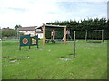
A right royal play area
The village of Kington St Michael acquired this site for recreation in the 1980s. It was levelled then and re-levelled in 2008 to provide a football pitch. In 2011 the Parish Council approved a Deed of Dedication for the recreation field to become a QEII Field. This raises the field to an accredited place of recreation that is enshrined in law. A roundel states it is a Field in Trust, as part of the Queen's Diamond Jubilee of 2012.
Image: © Neil Owen
Taken: 29 May 2021
0.22 miles
9
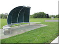
A shell shelter
This curious piece of furniture stands in the recreation ground at the north of Kington St Michael. It has a semi-circular alloy seating arrangement with four segmented panels to provide some cover. At the top are two modules, one with some lighting effects possibly; the other might be for acoustic use. It seems a little odd but presumably is used well.
Image: © Neil Owen
Taken: 29 May 2021
0.22 miles
10
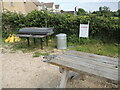
Kington St Michael barbeque facility
On the recreation ground is a community barbeque, currently padlocked but awaiting those balmy summer evenings.
Image: © Neil Owen
Taken: 29 May 2021
0.23 miles