IMAGES TAKEN NEAR TO
Ditteridge, CORSHAM, SN13 8PP
Introduction
This page details the photographs taken nearby to Ditteridge, SN13 8PP by members of the Geograph project.
The Geograph project started in 2005 with the aim of publishing, organising and preserving representative images for every square kilometre of Great Britain, Ireland and the Isle of Man.

There are currently over 7.5m images from over14,400 individuals and you can help contribute to the project by visiting https://www.geograph.org.uk
Image Map
Images are licensed for reuse under creativecommons.org/licenses/by-sa/2.0
Notes
- Clicking on the map will re-center to the selected point.
- The higher the marker number, the further away the image location is from the centre of the postcode.
Image Listing (7 Images Found)
Images are licensed for reuse under creativecommons.org/licenses/by-sa/2.0
Image
Details
Distance
1
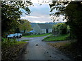
Approaching Ingalls Cottages
From the direction of Colerne.
Image: © Jonathan Billinger
Taken: 19 Nov 2013
0.01 miles
2
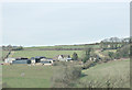
2008 : Ingalls Cottages north of Box
This group of buildings is named as Ingalls Cottages on OS Explorer 156 though it looks more like a farm.
Image: © Maurice Pullin
Taken: 25 Feb 2008
0.02 miles
4
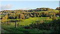
The By Brook valley
Box Hill is catching the rays of November afternoon sunshine.
Image: © Jonathan Billinger
Taken: 19 Nov 2013
0.04 miles
5
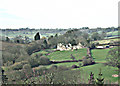
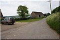
2008 : Slade's Farm, north of Box
On the A4 out of Box we get this view of Slade's Farm. Ingalls Cottages are a little way to the right on the same level. Just visible in the left background is Alcombe Manor with Banner Down behind.
Image: © Maurice Pullin
Taken: 25 Feb 2008
0.16 miles
6
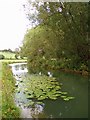
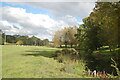
The By Brook
The By Brook flows in a south-easterly direction until it joins the river Avon at Bathford, on the outskirts of Bath. In spite of the dry weather, the brook appeared to be very full.
Image: © Sharon Loxton
Taken: 30 Jul 2006
0.20 miles