IMAGES TAKEN NEAR TO
The Woodlands, CORSHAM, SN13 8BW
Introduction
This page details the photographs taken nearby to The Woodlands, SN13 8BW by members of the Geograph project.
The Geograph project started in 2005 with the aim of publishing, organising and preserving representative images for every square kilometre of Great Britain, Ireland and the Isle of Man.

There are currently over 7.5m images from over14,400 individuals and you can help contribute to the project by visiting https://www.geograph.org.uk
Image Map (Loading...)


Getting Data...Please wait
Leaflet Map data © OpenStreetMap
Images are licensed for reuse under creativecommons.org/licenses/by-sa/2.0
Notes
- Clicking on the map will re-center to the selected point.
- The higher the marker number, the further away the image location is from the centre of the postcode.
Image Listing (9 Images Found)
Images are licensed for reuse under creativecommons.org/licenses/by-sa/2.0
Image
Details
Distance
1
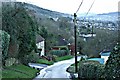
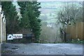
2008 : Lower Kingsdown Road (3)
Looking west along Lower Kingsdown Road as it approaches Wormcliffe Lane.
Image: © Maurice Pullin
Taken: 12 Jan 2008
0.06 miles
2
2008 : Wormcliffe Lane, Kingsdown
At least one very steep hill along here with some good views to make up for it.
Wormcliffe Lane heads north from Kingsdown to Ashley.
Image: © Maurice Pullin
Taken: 12 Jan 2008
0.07 miles
3
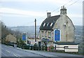
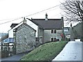
2008 : The Swan at Kingsdown
Perched at the top of the hill, probably the highest building in Kingsdown, The Swan has fine views to the north and west.
Image: © Maurice Pullin
Taken: 12 Jan 2008
0.08 miles
4
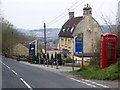
The Swan near Ashley
The inn is beside the old Bath road and has a K6 telephone box beside it.
Image: © Maigheach-gheal
Taken: 11 Apr 2010
0.09 miles
5
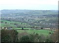
2008 : View from Kingsdown
The By Brook, the A4 and the main line railway between Bath and Paddington are at the foot of the valley before us and to the right.
Little Solsbury Hill Image stands in the top right hand third of the frame with the top of Lansdown running almost the whole width behind it. If you look carefully you can see Beckford's Tower. Image
Batheaston is this side of Little Solsbury.
This makes an interesting comparison with Image] which was taken from a spot near Brown's Folly.
Image: © Maurice Pullin
Taken: 12 Jan 2008
0.09 miles
6
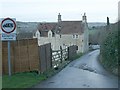
2008 : Off Lower Kingsdown Road
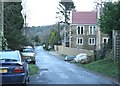
With a view of Ashley House at the bottom.
Image: © Maurice Pullin
Taken: 12 Jan 2008
0.19 miles
7
2008 : Lower Kingsdown Road
Lower Kingsdown Road takes the walker north along Kingsdown Hill for about half a mile then veers sharply to the right around the end of it. Some fine views along the way especially on a clear day, even better up the footpath at the end to the top.
Image: © Maurice Pullin
Taken: 12 Jan 2008
0.21 miles
8
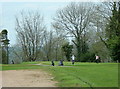
2008 : Action at Kingsdown Golf Course
Kingsdown Golf Club was founded in 1880, the second in the West Country. http://www.kingsdowngolfclub.co.uk/
Image: © Maurice Pullin
Taken: 26 Apr 2008
0.24 miles
9
2008 : Lower Kingsdown Road (2)
Looking east near the west end of Lower Kingsdown Road where it approaches the road from Bathford.
Image: © Maurice Pullin
Taken: 12 Jan 2008
0.25 miles