IMAGES TAKEN NEAR TO
Redhill Close, CALNE, SN11 9NY
Introduction
This page details the photographs taken nearby to Redhill Close, SN11 9NY by members of the Geograph project.
The Geograph project started in 2005 with the aim of publishing, organising and preserving representative images for every square kilometre of Great Britain, Ireland and the Isle of Man.

There are currently over 7.5m images from over14,400 individuals and you can help contribute to the project by visiting https://www.geograph.org.uk
Image Map
Images are licensed for reuse under creativecommons.org/licenses/by-sa/2.0
Notes
- Clicking on the map will re-center to the selected point.
- The higher the marker number, the further away the image location is from the centre of the postcode.
Image Listing (31 Images Found)
Images are licensed for reuse under creativecommons.org/licenses/by-sa/2.0
Image
Details
Distance
1
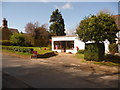
Derry Hill: post office/stores and postbox № SN11 128
An amenity the village is fortunate still to have.
Image: © Chris Downer
Taken: 4 Apr 2009
0.10 miles
2
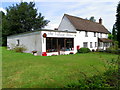
The Village Stores, Derry Hill
There is a small post office counter within the store.
Image: © Maigheach-gheal
Taken: 27 Aug 2010
0.13 miles
4
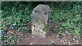
Old Milestone by New Road, Studley, Calne Parish
Stone post (plate lost) by the A4, in parish of CALNE (NORTH WILTSHIRE District), New Road, 400m West of junction with Studley Lane, on the verge, on South side of road. Bath limestone with iron plate, erected by the Calne turnpike trust in the 19th century.
Inscription reads:-
To
Bath
16
Rivet benchmark on the top with cut arrow on rear face.
Grade II listed.
List Entry Number: 1254373 https://historicengland.org.uk/listing/the-list/list-entry/1254373
Milestone Society National ID: WI_LB_BACN16.
Image: © A Rosevear / Jonathan Glew
Taken: 20 Jan 2016
0.14 miles
6
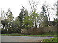
![Between the wood and the park [1]](https://s3.geograph.org.uk/geophotos/04/27/01/4270131_c802028f_120x120.jpg)
Between the wood and the park [1]
The footpath runs around the northern perimeter of Bowood Park, alongside Queenswood Plantation.
Image: © Michael Dibb
Taken: 6 Dec 2014
0.15 miles
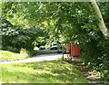
7
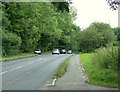
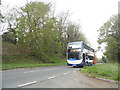
2009 : A4 near Studley looking west
Near the top of Derry Hill heading for Chippenham.
Image: © Maurice Pullin
Taken: 14 Jul 2009
0.15 miles
8
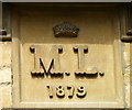
Date stone, Derry Hill
The date stone is to be found on Sunshine Cottage http://www.geograph.org.uk/photo/2041893
Image: © Maigheach-gheal
Taken: 27 Aug 2010
0.15 miles
10
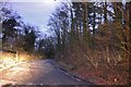
2009 : Layby off the A4
At the top of the hill through Derry Woods.
Part of the old A4 before re-alignment, makes a convenient place for a rest from driving. The A4 is to the left.
Image: © Maurice Pullin
Taken: 14 Jul 2009
0.16 miles