IMAGES TAKEN NEAR TO
Calstone, CALNE, SN11 8PZ
Introduction
This page details the photographs taken nearby to SN11 8PZ by members of the Geograph project.
The Geograph project started in 2005 with the aim of publishing, organising and preserving representative images for every square kilometre of Great Britain, Ireland and the Isle of Man.

There are currently over 7.5m images from over14,400 individuals and you can help contribute to the project by visiting https://www.geograph.org.uk
Image Map
Images are licensed for reuse under creativecommons.org/licenses/by-sa/2.0
Notes
- Clicking on the map will re-center to the selected point.
- The higher the marker number, the further away the image location is from the centre of the postcode.
Image Listing (28 Images Found)
Images are licensed for reuse under creativecommons.org/licenses/by-sa/2.0
Image
Details
Distance
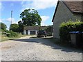
2
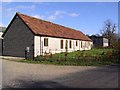
Converted farm building, Calstone Wellington
Image: © Chris Henley
Taken: 23 Nov 2006
0.09 miles
3
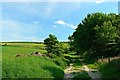
Footpath south of South Farm, Calstone Wellington
The footpath, which doubles as a farm track here, leads up the hill to a network of byways and bridleways encircling Morgan's Hill.
Image: © Brian Robert Marshall
Taken: 28 May 2012
0.11 miles
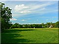
4
South along a footpath east of Calstone Wellington
South Farm is visible at the right of the image.
Image: © Brian Robert Marshall
Taken: 28 May 2012
0.13 miles
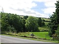
5
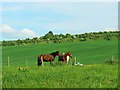
Horses in a field, Calstone Wellington
These beautiful animals are seen from a public footpath that runs south from the eastern end of the metalled highway through Calstone Wellington. Beyond the skyline is access land.
Image: © Brian Robert Marshall
Taken: 28 May 2012
0.13 miles
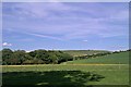
7
North along a footpath east of Calstone Wellington
South Farm is visible in the background. At the right is a field with a few horses within it.
Image: © Brian Robert Marshall
Taken: 28 May 2012
0.13 miles
8
View east from south of South Farm, Calstone Wellington
A footpath provides the viewpoint towards access land. Visible on the skyline is the Lansdowne Monument at SU048693, about 2 kilometres east north east from here. The monument is an obelisk erected by the third Marquis of Lansdowne in 1845 as a memorial to his ancestor Sir William Petty, an economist in the 17th century.
Image: © Brian Robert Marshall
Taken: 28 May 2012
0.17 miles
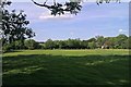
9
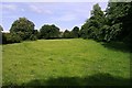
Pasture east of the Church of St Mary, Calstone Wellington
Lush grass lies within this small area of pasture. It may even be a paddock. There are horses hereabouts.
Image: © Brian Robert Marshall
Taken: 28 May 2012
0.19 miles
10
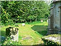
View east past the north elevation of the Church of St Mary, Calstone Wellington
The churchyard contains relatively few graves but there are one or two table tombs.
NOTE. This image has a detailed ‘shared description’ which you won’t see by viewing this image on a slideshow. To read it click on the image.
Image: © Brian Robert Marshall
Taken: 28 May 2012
0.19 miles