IMAGES TAKEN NEAR TO
Bourton, DEVIZES, SN10 2LJ
Introduction
This page details the photographs taken nearby to SN10 2LJ by members of the Geograph project.
The Geograph project started in 2005 with the aim of publishing, organising and preserving representative images for every square kilometre of Great Britain, Ireland and the Isle of Man.

There are currently over 7.5m images from over14,400 individuals and you can help contribute to the project by visiting https://www.geograph.org.uk
Image Map
Images are licensed for reuse under creativecommons.org/licenses/by-sa/2.0
Notes
- Clicking on the map will re-center to the selected point.
- The higher the marker number, the further away the image location is from the centre of the postcode.
Image Listing (38 Images Found)
Images are licensed for reuse under creativecommons.org/licenses/by-sa/2.0
Image
Details
Distance
1
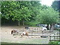
Horse and ponies
Seen from the road alongside the delightfully named Sloe Gin Cottage.
Image: © Michael Dibb
Taken: 29 May 2018
0.02 miles
2
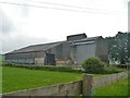
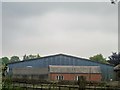
Barn in Bourton
A large unattractive building.
Image: © Michael Dibb
Taken: 29 May 2018
0.03 miles
4
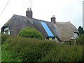
Three cottages
These three cottages, Windrush Cottage, Meadowsweet Cottage and Wansdyke Cottage are 16th or 17th century and are listed, grade II, with details at: https://www.historicengland.org.uk/listing/the-list/list-entry/1033736
Image: © Michael Dibb
Taken: 29 May 2018
0.07 miles
5
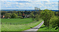
2012 : Lane to Bourton and Bishops Cannings
And view over the western end of the Vale of Pewsey.
Bourton is the hamlet on the other side of the wheatfield.
The north west escarpment of Salisbury Plane is on the far side of the valley.
Image: © Maurice Pullin
Taken: 11 May 2012
0.08 miles
6
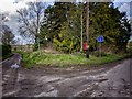
Bourton Near Bishops Cannings
This fork in the road is just North of the small hamlet of Bourton which in turn is just to the North of Bishops Cannings at the foot of Roughridge Hill at the West end of the Vale of Pewsey.
The lane comes from Bishops Cannings and splits at this point, the left going a short way to a track then a path leading up Roghridge Hill and the right leads to Easton Farm.
As can be seen from the signs in the picture both ways are dead ends.
Image: © Gillie Rhodes
Taken: 14 Feb 2013
0.12 miles
7
![Three ways to go [3]](https://s0.geograph.org.uk/geophotos/05/80/47/5804748_1771fc2e_120x120.jpg)
Three ways to go [3]
From the junction there are three ways to go. This is the road leading to Bourton and Bishops Cannings.
Image: © Michael Dibb
Taken: 29 May 2018
0.17 miles
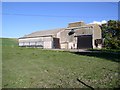
8
Bourton Manor Farm
Seen from the footpath.
Image: © Michael Dibb
Taken: 29 May 2018
0.18 miles
9
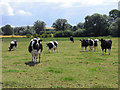
Pasture, Bishops Cannings
Cattle grazing at Easton Farm.
Image: © Andrew Smith
Taken: 12 Jul 2009
0.18 miles
10
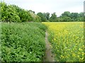
Along the field edge
After crossing a large field sub-divided into horse paddocks, the footpath now passes along the edge of this field.
Image: © Michael Dibb
Taken: 29 May 2018
0.18 miles