IMAGES TAKEN NEAR TO
Park Road, BANSTEAD, SM7 3BS
Introduction
This page details the photographs taken nearby to Park Road, SM7 3BS by members of the Geograph project.
The Geograph project started in 2005 with the aim of publishing, organising and preserving representative images for every square kilometre of Great Britain, Ireland and the Isle of Man.

There are currently over 7.5m images from over14,400 individuals and you can help contribute to the project by visiting https://www.geograph.org.uk
Image Map
Images are licensed for reuse under creativecommons.org/licenses/by-sa/2.0
Notes
- Clicking on the map will re-center to the selected point.
- The higher the marker number, the further away the image location is from the centre of the postcode.
Image Listing (50 Images Found)
Images are licensed for reuse under creativecommons.org/licenses/by-sa/2.0
Image
Details
Distance
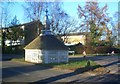
2
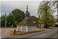
Well head
18th Century well head at the junction of Woodmansterne Land and Park Road, still with its winding gear over a 300 foot deep well. Grade II listed - see www.historicengland.org.uk/listing/the-list/list-entry/1178243.
Image: © Ian Capper
Taken: 27 Oct 2018
0.03 miles
3
Banstead
The old village well stands to the east of the town centre, in Woodmansterne Lane. It is almost 300 feet deep and was last used around the end of the 19th century. The wellhead cover dates from the 18th century and holds old winding gear.
Image: © Peter Trimming
Taken: 11 Aug 2021
0.03 miles
4
Banstead village well
This wooden building in Banstead is a wellhead. Within it, the well is 300 feet deep.
The well head is a Grade II listed building, which was restored in 2003. More information about the well head is available on the Banstead History website: https://www.bansteadhistory.com/places_az.html , with another article describing the restoration: http://bansteadhistory.com/well_feature.html
Image: © Malc McDonald
Taken: 11 Jan 2020
0.03 miles
5
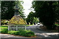
The Old Well in Banstead
The Old Well was a public well used by the people in the village until the arrival of pumped water. The 18th century wellhead cover which still houses the elaborate winding gear is a listed building. The well shaft is some 300 feet deep and still exists today. In 2003, the well housing was completely refurbished - see http://www.bansteadhistory.com/well_feature.html
Image: © Marathon
Taken: 4 Nov 2013
0.03 miles
6
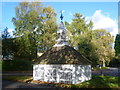
Banstead Village Well
The Old Well was a public well used by the people in the village until the arrival of pumped water. The 18th century wellhead cover which still houses the elaborate winding gear is a listed building. The well shaft is some 300 feet deep and still exists today. In 2003, the well housing was completely refurbished - see http://www.bansteadhistory.com/well_feature.html
Image: © Marathon
Taken: 4 Nov 2013
0.03 miles
8
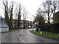
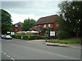
Woodmansterne Lane at the junction of Park Road
Coming into the centre of Banstead
Image: © David Howard
Taken: 14 Jan 2013
0.03 miles
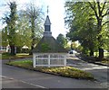
9
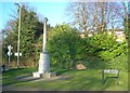
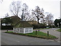
The Banstead War Memorial
110 men's names listed from WW1 & WW2
Image: © The Saunterer
Taken: 19 Feb 2013
0.03 miles
10
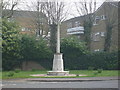
Monument, Banstead
Monument on Road junction, Banstead.
Image: © Henry Spooner
Taken: 22 Apr 2009
0.03 miles