IMAGES TAKEN NEAR TO
Clarice Way, WALLINGTON, SM6 9LD
Introduction
This page details the photographs taken nearby to Clarice Way, SM6 9LD by members of the Geograph project.
The Geograph project started in 2005 with the aim of publishing, organising and preserving representative images for every square kilometre of Great Britain, Ireland and the Isle of Man.

There are currently over 7.5m images from over14,400 individuals and you can help contribute to the project by visiting https://www.geograph.org.uk
Image Map
Images are licensed for reuse under creativecommons.org/licenses/by-sa/2.0
Notes
- Clicking on the map will re-center to the selected point.
- The higher the marker number, the further away the image location is from the centre of the postcode.
Image Listing (43 Images Found)
Images are licensed for reuse under creativecommons.org/licenses/by-sa/2.0
Image
Details
Distance
1
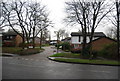
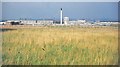
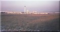
Former Croydon aerodrome, 1968
From the same spot as Image] and Image], looking to the left across an area of open grassland that is now allotments, woodland and further housing. Some of the first rows of flats on the Roundshaw estate have been completed along Mollison Drive.
Image: © Derek Harper
Taken: Unknown
0.03 miles
2
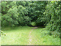
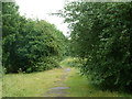
Path, Roundshaw Downs
Towards the more open part of the downs.
Image: © Robin Webster
Taken: 6 Jun 2011
0.04 miles
5
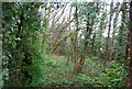
Path, Roundshaw Downs
Towards the more open part of the downs.
Image: © Robin Webster
Taken: 6 Jun 2011
0.09 miles
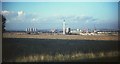
7
Former Croydon aerodrome, 1968
Fewer cranes are in evidence than seven months earlier in Image; blocks of flats have appeared in front of the cooling towers and power station.
Image: © Derek Harper
Taken: Unknown
0.09 miles
8
Snow on the aerodrome, 1968
Not a lot of change in the eight months since Image was taken, but it's a white Christmas.
Image: © Derek Harper
Taken: Unknown
0.09 miles
9
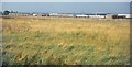
Former Croydon aerodrome, 1967
The view looks across the chalk grassland of the aerodrome, which closed in 1959. There is now woodland and allotments in the foreground area. Showing the progress on the Roundshaw estate since Image was taken, with a tall chimney on the communal boiler house of a centralised heating system. The first tenants had moved in to the estate the previous month. To its left is the Croydon B power station and some cooling towers; central Croydon is to the right.
Image: © Derek Harper
Taken: Unknown
0.09 miles